Gunung Korbu |
| Location | Pahang-Perak, Malaysia |
|---|---|
| Height |
Gunung Yong Yap - 2163 m Gunung Bubu - 1974 m Gunung Korbu - 2813 m Gunung Gayong - 2173 m Gunung Yong Belar - 2181 m |
| Terrain | Mixed forest trail, river crossings |
| Recommended duration | 8 days, 7 nights |
| Ease of access | 4-wheel drive to starting point of trek |
| Special equipment | None |
| Good | Covers the 2nd, 3rd, 4th and 6th highest mountains on Peninsula Malaysia |
| Not so good | Leeches and sandflies. Frequent rain in the afternoon. |
Blog post, Yeh Shu Mei from Taipei Taiwan
04 January 2016
This was a 7-person team from Taiwan guided by Ayieen with 2 porters. The guide took care of everything including 4WD vehicles.
We had a very hard but fabulous time there. Thank everyone who joined us.
Unexpectedly, there were not so many leeches, but sandflies were a nuisance. Head mosquito net and mosquito coil are recommended for this trek.
Period:Sep. 28-Oct. 5, 2015
D0: Meet our guides and porters at Tanah Rata apartment.
D1 : Cameron Highlands Tanah Rata - Sg Rengget - Blue Valley Dam - Kem Tudung - Kem Kasut
| 1030 | BVD vegetable garden. After brief pray we began the journey. Walked along the car road. |
| 1140 | Actual start point. |
| 1200 | A gentle slope. |
| 1350 | Kem Tudung. Here we cooked our noodles for lunch. Water point was just 1-minute walk away. |
| 1500 | Continued hiking. The trail became more and more difficult. |
| 1735 | Kem Kasut. |
| 2100 | The other guys and porters arrived with torch light at last. So we set up the tent and cooked our dinner. |
D2: Kem Kasut 1780 m - Yong Belar 2181 m - Kem Kuali - H2O peak - Kem H2O 1560 m
| 0840 | The Malaysian team prayed before start. We carried our own food and tents, and began ascent to the peak. |
| 0940 | G.Yong Belar. We could see G.Korbu and Gunction in the north, but later the cloud covered the mountains. The gibbons were howling in the valley. Ayieen said the more sunshine the more howling! There were also lots of pitchers hanging on the tree. |
| 1110 | Kem Kuali. Lunch time. Water was 2-minute walk from here. |
| 1235 | From G.Yong Belar to Kem H2O was about 7km walk. Lots of up and down and then all the way down. The trail was very difficult because of the slip trail and many collapsed trees and numerous obstacles. |
| 1350 | Heavy rain. A surprising thing to us was that we saw our guide drink the water on the leaves. |
| 1450 | H2O peak. |
| 1650 | Kem H2O. The campsite beside a creek was very wet and muddy. As always we set up our shelter and equipment first and then cooked dinner. We saw fireflies in the dark woods. What an amazing night! |
D3 Kem H2O - G.Junction 2088 m - Kem Cerek
| 0820 | Began ascent to the peak. |
| 0850 | Last water point. We filled up our water bags for lunch. |
| 0915 | A cliff. It was a tough trip to walk through. |
| 1150 | Broad and flat G. Junction peak. Happy lunch and rest time. The Malaysian team smoked and refilled their energy. We left some things here and took stuff for one day and night to the next campsite. |
| 1350 | It began raining when we went down to Kem Cerek. The road was very steep, so you must use your four limbs and climb downward slowly. |
| 1620 | Kem Cerek. Narrow ridge campsite. Water source was 10-minute down and 15-minute up away. The space was crowded. Rainy all night. |
D4 Kem Cerek - G.Korbu 2183 m - G.Gayung 2173 m - Kem Cerek - G.Junction - Kem MIT
| 0710 | What a wonderful day! We were so lucky because of no rain. We start trekking with daypacks, just like an excursion. |
| 0745 | One of the roads at the fork was to G.Korbu and the other was 5-minute to G.Gayung. |
| 0810 | Avatar scene. There were beautiful moss forests all the way. It was so magnificent that all of us really enjoyed it! |
| 0920 | G.Korbu. The peak had a border stone with Perak on one side and Pahang on the other. |
| 1020 | Go back along the same way. |
| 1125 | G.Gayong. It was similar to Korbu because we saw nothing due to the fog. We took a break here. |
| 1210 | Kem Cerek. During our lunch time it started raining heavily. |
| 1340 | G. Junction. It was very very hard to climb up to Junction. |
| 1540 | Repacked our knapsack. |
| 1610 | Descent to Kem MIT. The way was just like green tunnel that you must crawl most of the time. Our gloves, clothes and pants all became wet and muddy. It was the toughest physical challenges for us. |
| 1810 | Kem MIT. The campsite was situated on the woods ridge and there were sandflies heaven. Our guide set up fire to chase those flies away. We then cut some trees and lined up our tents and shelters in order. What a big day! The water point was 25-minute down and 15-minute up. |

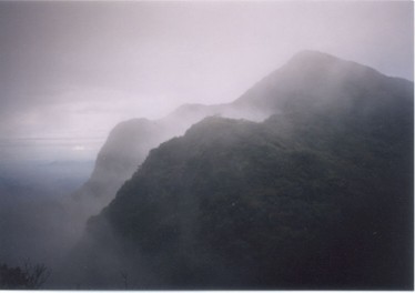
Mossy forest trail (image courtesy of Yeh Shu Mei) |
D5 Kem MIT - Kem Lembah Agas 1645 m - Bonsai Tengah - Puncak View - Kem DGU 1540 m
| 0845 | Set off. |
| 0925 | Kem Lembah Agas. A stream went through the campsite. |
| 1015 | Set off. |
| 1250 | Bonsai Tengah. Happy lunch time! |
| 1430 | Puncak View. 360-degree good view! Beautiful cloud and fog! |
| 1515 | Kem DGU. (Don't give up). This campsite was the middle point of this trekking. Leisure time! The Malaysian people took a bath in the cold stream, so we thought they were strong. We cooked our dinner unhurriedly. |
D6 Kem DGU 1540 m - Puncak Belumut - Kem Kacang - Puncak Kayong - Puncak Tok Nenek 1905 m - Puncak Kayong - Kem Lopak air 1642 m
| 0855 | Set off. |
| 1050 | Puncak Belumut. We were so tired that our pace was slow. |
| 1200 | Kem Kacang lunch. Traditionally Malaysian people have big breakfast, good lunch and simple dinner. |
| 1450 | Kayong peak. We could see Tok Nenek in front of us. |
| 1510 | Puncak Tok Nenek. 360-degree good view! Limestone terrain was easy to climb, so we spent lots of time enjoying the landscape there. |
| 1730 | Kem Lopak Air. Wet and muddy campsite. Water source was near here. |
D7 Kem Lopak air - G.Bubu - Simpang Yong Yap 1950 m - G.Yong Yap 2168M - Simpang Yong Yap - Kem Balak - Kem sg Y - Kem Agas 1153 m
| 0840 | Set off. |
| 1000 | G.Bubu. Beautiful sunshine and the gibbons were howling in the valley. We dried our clothes and gears. |
| 1135 | Set off. |
| 1410 | Simpang Yong Yap. Quick lunch. |
| 1510 | Heading for the final peak. The trails were very steep. |
| 1550 | G.Yong Yap. We hugged each other to celebrate that we conquered the V2 traverse. We made it! |
| 1800 | Kem Balak. Crossed some rivers in the dark. |
| 1920 | Kem Agas. A broad and flat campsite beside river. |
D8 Kem Agas - Simpang Tok Nenek Yong Yap - Kampung Sg Rengi l744 m
| 0850 | Set off. About 5-hour non-stop trekking. Along the way, we had to cross some rivers, most of which were below knee level. |
| 1000 | Bamboo trail. Many bamboos collapsed so we must crawl. |
| 1100 | Simpang Tok Nenek Yong Yap. Nice campsite. |
| 1120 | Deer footprints in the mud. |
| 1210 | Car road. Some cultivated land. |
| 1420 | Kampung Sg Rengil. The end of the memorable adventure. We were proud that we had overcome our mental struggles and physical discomforts for the past 8 days. Kampung Sg Rengil is an aboriginal village. The people were very friendly. |
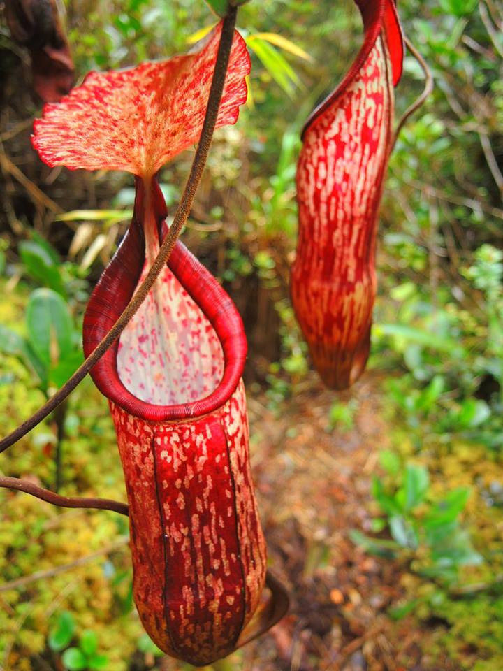
Pitcher plant (image courtesy of Yeh Shu Mei) |

Trans Titiwangsa v2 route |

Trans Titiwangsa v2 elevations |