Gunung Korbu |
| Location | Pahang-Perak, Malaysia |
|---|---|
| Height | Gunung Korbu - 2813 m Gunung Yong Belar - 2181 m Gunung Gayong - 2173 m |
| Terrain | Mixed forest trail, river crossings |
| Recommended duration | 5 days, 4 nights |
| Ease of access | 4-wheel drive to starting point of trek |
| Special equipment | None |
| Good | Covers the 2nd, 3rd and 4th highest mountains on Peninsula Malaysia |
| Not so good | Leeches and sandflies. Frequent rain in the afternoon. |
Blog post, from The MtTrekker
December 2000
Titiwangsa range, also known as the main range, stretches over 350 km long and contains some of the highest mountains in Peninsula Malaysia. The popular tourist area of Cameroon highland is also part of the main range. The main range is also one of the wettest regions of in Peninsula Malaysia. Its mountains, many of which are more than 1500m high, pushes up the water-laden clouds from the Straits of Malacca to deposit its load on the mountains. Lots of rain can be expected on this trek.
Titiwangsa traverse crosses three of the four highest mountains in Peninsula Malaysia, Gunung Korbu, the second highest at 2183m, Gunung Yong Belar, the third highest at 2181m and Gunung Gayong, the fourth highest at 2173m. Gunung Tahan, standing at 2187m is the highest mountain in Peninsula Malaysia, but it is not located in the main range. Due to the high rainfall in the main range, the vegetation found on these mountains is thicker and different from those on Gunung Tahan although Gunung Korbu is only four meters lower than Gunung Tahan.
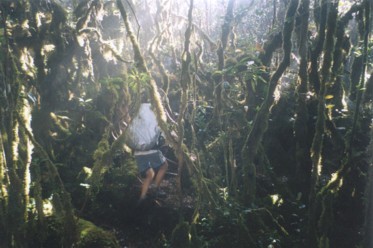
Mossy forest at higher altitudes along Titiwangsa range |
The expedition usually starts from Cameroon Highland and ends in a small settlement near Ipoh and takes about 5 days to cover. This direction of travel is understandably preferred as it starts from a higher ground and ends on the lower ground. The trek involves walking on old logging trails and some river crossings especially on the last day of the trek. Parts of the trek can be challenging as it passes through primary rainforest and mossy forest at higher altitude. At the mossy forests, there are many fallen trees and tangles of moss covered branches which you have to crawl under them. As the trek covers three mountains, the route takes you down long descents before ascending up the next mountain.
There are many other challenges on this trek. Although it rains in the afternoon, water source can be a problem. A lot of distance needs to be covered on the first day of trek to Gunung Yong Belar summit. It is usually dark when the camp is set up at the summit and water has to be brought from the last water source which is about one and a half hour before the summit. The route to that water source is also not well defined and it is a 10-minutes steep descend from the trail. At night, the temperature can fall to about 10 °C.
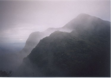
Gunung Gayong summit view |
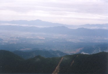
The next day is a descent to a campsite beside a river. However, the campsite is infested with sandflies. A burning mosquito coil will be useful to keep the sandflies away. The following day's trek to the summit of Gunung Gayong is more difficult. The last water point before the summit is an hour's trek away. However, to reach the water source, one has to make a very steep descent down the side of the ridge through primary forest and loose soil for about 20mins. The return journey usually takes about an hour. From the campsite at the top of Gunung Gayong, the town of Ipoh can be seen.
Day 4 of the trek is perhaps the easiest day. The time taken to come down from Gunung Gayong and climb up to the summit of Gunung Korbu is just over 2 hours. Clouds may cover Gunung Korbu summit and nothing can be seen. From the summit, it is a straight descent to another sandfly infested campsite beside a river. The last day of the trip is a relatively easy trek with little ups and downs. However, there are many river crossings to be made although the water level is not very high. The rest of the route to the ending point is also infested with tiger leech.
The challenge of Titiwangsa Traverse trek is comparable to that of Gunung Tahan trek. Unfortunately, the sceneries from the summit of these three mountains is usually limited by thick vegetation and poor visibility. Frequent rain in the afternoon also made the trek difficult at times. This trek is recommended for people who had trek in other mountains in Peninsula Malaysia and want something more challenging. Due to the remoteness of this region, a good guide is essential.

- SMUX Trekkers, 16 October 2010.
- pondoktiga, 15 October 2008.

Take a bus to Tapah1
| Sri Maju Sarata Ekspres (Singapore to Ipoh) | ||
| Bus timing | : | ...2200 hrs... |
| Cost | : | RM 40 per person |
| Duration | : | 6 hrs 20 min |
| Remarks | : | Super VIP (1 free small mineral water per person) Buy bus ticket from counter 36 Bus stop outside Restoran Caspian (agent for daily express bus) in Tapah |
From local bus terminal (along Jalan Raja) to Tanah Rata1
To get to local bus terminal, facing the foodstall, go left along the main road. At the first junction where there is a Kentucky Fried Chicken (KFC), turn right. Local bus terminal is on the left side of the road.
|
Bus company: Regal Transport Co. Ltd Cost: RM 4.70 per person (RM 5 per person for air-conditioned bus) Duration: 2 hrs Remarks: Buy tickets on bus |
From Tanah Rata to Kumpong Raja,1
|
Regal Transport Co. Ltd Bus timing: 0800 hrs (first bus) Cost: Rm 2.40 per person Duration: 50 mins Remarks: Buy tickets on bus |
From Kumpong Raja to starting point,1
|
Private 4-wheel drive Cost: Rm 50 per vehicle Duration: 25 mins Remarks: ask locals |
Return journey from Tanjong Intik to Tanjong Rambutan1
|
Private van Cost: Rm 3 per person Duration: 15 mins Remarks: ask locals |
From Tanjong Rambutan to Ipoh1
|
Taxi Cost: approx RM 10 per vehicle Duration: 30 mins |

| Time(hrs) | Duration(mins) | Description | Remarks |
|---|---|---|---|
| 0850 | 00 | Kumpong Raja | |
| 0915 | 25 | 4-wheel drive ride to starting point | |
| 0940 | 25 | Starting point | |
| 1000 | Set off (200 steps) | ||
| 1040 | 40 | Dam across river | Walk on dam across river |
| 1150 | 70 | Mossy forest | |
| Up and down knolls | |||
| 1450 | 3hrs | Water point | |
| 1700 | 2hrs 10min | 6352 summit | |
| 1820 | 1hr 20min | Water point | Steep descend down path on left side of route for 10mins |
| 2000 | 1hr 40min | Yong Belar Summit | |
| DAY 2 | |||
| 0925 | 00 | Set off | |
| 1040 | 1hr 15min | Water point | Small trail on the right down to a valley |
| 1345 | 2hrs 5min | 6470 summit | |
| 1645 | 3hrs | Campsite in a valley beside stream | Sandflies |
| DAY 3 | |||
| 0900 | Set off | ||
| 0915 | 15 min | Cross stream | |
| 0940 | 25 min | Cross stream | |
| 1050 | 1 hr 10 min | 5800 summit | |
| 1325 | 2 hrs 35 min | 6852 summit | |
| 1645 | 3 hrs 20 min | Water point | Steep descend on left side of trail to a valley for 20 min. Sandflies and leeches are present at water point |
| 1800 | 1 hr 15 min | Set off | |
| 1900 | 1 hr | Gayong summit | |
| DAY 4 | |||
| 0915 | 00 | Set off | |
| 1130 | 2 hrs 15 min | Korbu summit | |
| 1210 | Set off | ||
| Steep descend and very muddy path | |||
| 1520 | 3 hrs 10 min | Water point | |
| 1640 | 1 hr 20 min | Campsite beside river | sandflies |
| DAY 5 | |||
| 0920 | Set off | ||
| 1040 | 1 hr 20 min | Pondok | |
| 1130 | 50 min | Rest | |
| 1145 | 15 min | River crossing | Set off |
| 1220 | 35 min | River crossing, twice | |
| 1240 | 20 min | River crossing | |
| 1310 | 30 min | River crossing | |
| 1340 | 30 min | Pondok | Rest |
| 1420 | 40 min | Set off | |
| 1520 | 1 hr | Large bridge | Cross bridge |
| 1610 | 50 min | End of road | Tanjong Intik |

- Outdoors Sandals
- Light weight clothes
- Tent
- Groundsheet
- Gas stove and canister
- Lamp/torch
- Pots for cooking/ Mess Tin
- Small Shovel
- Nylon string
- Water Purification Tablets
- First Aid Kit
- Toiletries
- Toilet Paper
- Extra clothing
- Kitchen utensils (Fork, Spoon)
- Rain gear
- Sleeping bag
- Cap/Hat
- Windbreaker/Jacket
- Lighter
- Swiss Knife
- Insect repellent
- Water container