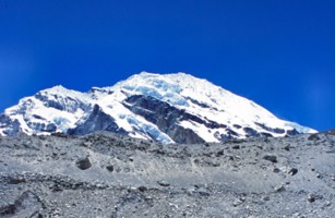
Parchamo as seen from the basecamp (May 2003). |
| Location | Parchamo peak, Rolwaling Himal, Nepal |
|---|---|
| Highest point | 6187 m |
| Terrain | Lowland forest trail, Highland trail, Rock, Ice and Snow |
| Recommended duration | At least 15 days |
| Ease of access | Plane to Lukla |
| Special equipment | Mountaineering gears |
| Good | Varied terrain with some technical challenges |
| Not so good | No access to true summit |
|
Height : 6187m (20,293ft.) Location : Rolwaling Himal, Nepal Latitude: 27 49 40 Longitude: 86 32 45 First climbed : 1955. Dennis Davis and Phil Boultbee |
10 May - 29 May 2003
When anybody talks about climbing in Nepal, the first thing that comes to people's mind would be Mt Everest. However, there are many other peaks in Nepal that are worth climbing. Parchamo is one of them. Although categorized as a trekking peak under Nepal Mountaineering Association, it is by no means an easy mountain to climb. This mountain is no base camp trek. It involves a higher element of risk taking, much higher fitness level and for Parchamo, a certain level of technical skills is required. Even for a trekking peak in Nepal, dangers such as avalanches and crevasses (a gap in the ice that can be more than 5 storeys deep) are to be expected.
Parchamo is found at the edge of the Rolwaling valley, which is a neighboring valley of the Solo Khumbu (Mt Everest region). This region was first explored by Shipton in 1952. However, it was not until 1955, when Dennis Davis and Phil Boultbee reached the summit of this mountain. Generally, this mountain can be approached from two different directions, one is from the Rolwaling valley and the other is from the Solo Khumbu valley. Although the approach from the Rolwaling valley may be more scenic as mentioned in many trekking diaries, the approach from the Solo Khumbu valley is much faster which is also the route that my team had taken.
The cultural shock begins immediately after we step out of the airport. Porters would be flocking to help carry our bag. There would be no escape or refusal. Their helpfulness soon becomes clear when they ask for tips after the bags were loaded onto the vehicle. While on the main tourist street of Thamel, Kathmundu, people and vehicles move side by side and frequently on the verge of collision. It seems that miracles were happening every second on the streets of Kathmundu. The single syllable language (honking of the vehicle) used on the streets seem to convey a lot of meaning behind it, although the new arrivals would not be able to make any sense out of it. To survive the mountain, we must first survive the city.
Away from the city, the traditional culture of the Nepali can be seen. Their perseverance, adaptability and hardworking nature are everywhere for all to see. Their houses are made of granite rocks. Each rock is meticulously chipped into blocks using just hammer and chisel and laid on top of one another. Both men and women can be seen carrying heavy loads weighing as much as 40kg when we walk along the trail. Schools are few and far between. The children have to walk for as long as 2 hours to reach the nearest school. They are the lucky ones. Others may not even have the chance to study, either because the school is too far away or they have to help in the farm. Such was the qualities of Nepali shaped by the harsh condition of the mountains.
Our expedition began in Lukla. The trek to the base camp may seem straight forward on paper, but that was not our destination. We had to make sure that our body was in optimum when we were at the base camp. This was by no means easy. Other then battling the cold and altitude, we must be able to adapt to the local food and living conditions. Out there, there was no flushing toilets, no television and no heater in the cold Himalayan night. Despite our vigilance, two of our climbers were down with diarrhea on the second day of our trek. Fortunately, the whole team was fit again by the time we reached Parchamo base camp at 4600m.
Reaching the base camp was not easy, to the high camp and staying there was much more difficult. The path to the high camp was laden with snow and ice. Not to mention a steep slope which required the use of a rope just before we reach the high camp. At 5600m, the high camp certainly poses its own set of problems. Even a few of our supporting crew (local Nepali), was suffering from its effect, and some of us were also affected by mild cases of altitude sickness.
|
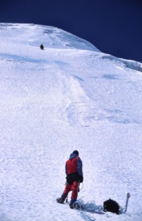
| 200m ascent, with slopes of up to 80 degrees(May 2003). |
Looking at Parchamo from the high camp, it really looks like a big ice cream. But this was one tough ice cream to climb. The start of the climb seems reasonable with slopes of about 30 degrees. But this was just the prelude. A 70 degrees slope up to 200m high soon greeted us. It was there where our technical skills come into play. With one hand on the fix rope and the other on the ice axe, we kicked our crampons into the hardened snow and made our way up. After the steep section, the most difficult part was over, but the rest of the way was by no means a walk in the park. With each step feeling as if I had completed a 5km run, the summit was so near yet so far. Moreover, our legs were never given any chance to rest, either we were going up a slope or traversing it with our ankles straining at the angle, which they were placed on the slope. To add some excitement to the climb, there were crevasses as well as cornices to overcome. The cornices, although less 'well-known' then the crevasse were very dangerous. Falling through one would mean falling off the side of the mountain literally. From where we were, it would mean a one-way express ticket back to the base camp 1500m below.
After a final 50m steep ascend which required a fix rope, to the summit ridge, our guide tell us that this was the end of our journey. Our wrist top computer registered 6120m. The true summit was not far away at 6187m. But it was apparent that the journey along the ridge to the true summit was too dangerous. It was covered with cornices and crevasse which only the most experience and well-equipped team could attempt to reach it. According to local climbing guides, there were very few teams that make it to the true summit over the pass ten years due to the presence of huge crevasses and for most climbers, this was the summit of Parchamo. And so, at 6120m, we had arrived at our summit of Parchamo.
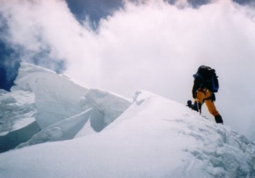 Cornices formed on the mountain ridge can be very dangerous(May 2003). |
For most people, their adventure ends at the summit, after all, it was just back tracking on the way down. It was certainly not true for our case. As we leave the summit, the weather quickly turned bad. A total white out with visibility less than 50m soon descended upon us, and a snowstorm started to sweep across the mountain. The only consolation we had was that we were very near our campsite, less than half an hour walk under normal circumstances. But with the white out, we were not able to see the campsite or any landmarks to guide us back. With crevasses on the mountain, we had to be careful where we tread. With the weather clearing slightly, our guide was able to make out some features and we slowly made our way back to our campsite. We must had trapped out there for more than an hour.
Just as we thought that everything would be smooth going, the next morning, one of our teammates had knee injury that was so bad that he could hardly bend them. As a matter of fact, he was not able to walk, let alone trekked down to base camp. But, with the help of our assistant guide, we were able to send him down the mountain. Although painkillers provide temporary relieved from the pain, it soon become apparent that a heli-evacuation was necessary when the pain returned the next day.
With the end of each expedition, there would be a party just before we return to Kathmundu where everybody, porters, cooks, guides and of course ourselves, party and make merry. This was definitely the finale of the expedition. Everybody danced to the local music and drink the local brew called chang.
Despite all the difficulties that we had faced, this is still a wonderful experience for me. For those who wanted to do more than a base camp trek, then perhaps, it is time to try a trekking peak. However, the trekking peaks have varying difficulties and technical skills required not to mention that all of them are high with very real danger of getting acute mountain sickness. However, with careful planning and lots of training, especially on the physical side, getting up a less technical trekking peak like the summit ridge of Parchamo should not be a problem.
| Route Description (As of May 2003) | |
|
DAY 1: Trek from Lukla (2850m) to Phakding (2652m), 3hrs The route is mostly descending with a few ups and downs. Houses are scattered along the route to Phakding. The trail is well defined but dusty. Kwangde can be seen clearly behind the hills. DAY 2: Phakding to Namche Bazar (3440m), 6hrs The ascent is gradual before reaching the Sagarmatha National Park Entrance. Tam Shirku can be seen clearly from the valley. After registration, the road leads down to the Dudh Kosi (river) before making an ascent to a bridge that stretches high across the Dudh Kosi. The ascent from here is steep and thus, tiring. In Namche Bazar, there are many shops selling mountaineering gears and of course, souvenirs and books. There are also internet connections but the cheapest rate was Rs15 per minute while the normal rates are Rs20 per minute. There are also moneychangers, although the rate is not as good as those in Kathmundu and postal service. Kwangde can be seen clearly from Namche Bazar. DAY 3: Acclimatization climb to Syangboche airfield (3700m), 2hrs to airfield Syangboche airfield is located at the top of the ridge over Namche Bazar. The ascent is steep and it passes through many small trails. There are several routes that can be taken to reach the Syangboche airfield. From the top of the ridge, the whole of Namche Bazar can be seen. DAY 4: Namche Bazar to Thame (3800m), 3.5hrs The trail breaks off from the popular Everest Base Camp trail from here. The trail now turns west along Bhote Kosi (River) to Thame. The initial part is relatively flat with some gradual descent passing through conifer forest and rhododendrons. After Thamo, it is mostly ascending. A bridge high above Bhote Kosi is crossed to bring us into the valley of Thame Khola (River). From Thame, snowcap-mountains can be seen stretching as far as the eye can see along the left side of the valley. Parchamo, however, is still out of side. The Thame monastery is the last monastery along the route to Parchamo. It would be good to pray for safety and success of the expedition at this monastery. This is also the last permanent settlement. DAY 5: Thame to Thyangba/Thengpo (4320m), 3.5hrs The trail leads into the valley of Thame Khola. After an initial steep ascent, the rest of the journey is relatively gradual ascent along a small trail. The vegetation here are getting lower and it is less dusty here. Just before reaching the temporary settlement of Thyangba, the trail enters a beautiful plain with numerous small channels where the water flows. The temporary settlement can be seen from here. Thyangba is the summer grazing ground of yaks. It is very common to see herders herding their yaks through this area. At this altitude, there would be light snowing in the afternoon although there are no permanent snows on the ground in the summer. DAY 6: Acclimatization climb (4780m), 2.5hrs to highest point The acclimatization climb involves going up a small knoll just by the side of Thyangba. There are no trails that lead up the knoll. There are scree slopes and scattered vegetation on the knoll. The ascent is steep and care has to be taken when walking on the scree slopes. From the top of the knoll, Parchamo peak can be seen. DAY 7: Thyangba to Base Camp (4830m), 3hrs The trail leads deeper into the valley of Thame Khola. The ascent was gradual for most of the way. Just before reaching the base camp, there is a ridge that is about 100m high blocking the way. It consists of loose rocks and is very steep. Although a rope is not necessary, the ascent is very energy sapping. The base camp is at the other side of ridge lower down. Parchamo can be seen very clearly from here. This is also the last camp where liquid water can be collected. The ground consists of bare rock but they are not snow covered. The sunlight can get quite intense at this high altitude.
DAY 8: Acclimatization climb (5120m), 2hrs to highest point The acclimatization climb includes going up the route that we are going to take to the high camp. The path involves going up a small scree covered ridge before going up towards the high pass. The initial part of the climb is on bare rocks, but higher up, pass 5000m, snows start to cover the ground. The trek up till this point is quite steep. DAY 9: Base camp to High camp (5600m), 6hrs After the initial trek of about 3hrs, which consist mainly of walking on rocks, the rest of the journey is mainly on snow-covered ground. Once on the snow-covered ground, the trail is quite a gentle ascent. But after about 1hr, the ascent becomes steep, up a scree slope with stretches of snow-covered slope. Just before reaching the high camp, there is a very steep ascent of about 50m vertical heights that requires fix rope. It would be safer to make use of jumar and a helmet should be worn. The high camp was located beside an inclined cliff. Parchamo can be seen clearly from here. The tents were pitched on the snow-covered ground. DAY 10: Acclimatization climb (5800m), 1hr to highest point The acclimatization climb takes us up Parchamo. We stop just short of a very steep and high section while the guides climb up to anchor the 200m long fix rope. DAY 11: From high camp to Summit ridge (6120m), 8hrs to summit ridge, 5hrs to return For the summit attempt, we wake up at 1.30am and get ready to set off at 3.00am. The morning snow condition is very good. We quickly reach the base of Parchamo. The initial climb involves walking on a 45o slope that is about 20m long. There is a fix rope left behind by a previous expedition but it is not necessary to use it. It is followed by a very steep section, with slope up to 80o. Jumar is required to move up the 200m long fixed rope up the slope. The fixed rope is anchored at 4 points with an anchor on each end of the rope. Close to the middle section of the slope, there is a band of ice about 1.5m high. After overcoming the 200m high steep slope, there is a relatively flat land to rest on. The route then turns left with narrow crevasses that cross the path. There are more slopes of about 40o to ascent. More crevasses are found across the path. The route then goes straight along the side of a ridge. At some point, it is necessary to go up the slope of the ridge which has a gradient of about 70o. The ascent is about 50m with fixed rope to assist in the ascent. At the top of the ridge, care has to be taken to keep to the right side of the ridge due to the presence of cornices. After walking along the ridgeline, the route then turn left up another slope to the summit ridge which is the end point of the climb. From here, the true summit is said to take another 6hrs to reach. However, cornices and crevasses make it impossible to reach the true summit of Parchamo at 6187m without the use of ladders according to our guide. |


HIMALAYA EXPEDITION
Nuwakott Ghar, Sanepa Chowk, PO Box: 105,
Kathmandu / Nepal
Tel: 01 554 5990, 554 5900, Fax: 01 552 6575
E-mail: bikrum@HimexNepal.com
Website: www.HimExNepal.com
| Description | Cost | Remarks |
| Travel | ||
| Singapore to Kathmundu and back | S$675 per person | Thai airway |
| Singapore Airport Tax | S$57 per person | |
| Excess Baggage cost:Domestic flight (Kathmundu to Lukla) | approx. US$1 per kg per flight | There is usually no restriction in the size of the hand carry bag |
| Permits | ||
| Visas | S$65 per person | |
| Trekking peak fees | S$700 for my team of 5 climbers | |
| Package Costs | ||
Includes
Excludes
|
About S$8000 for my team of 5 | |
| Labour Cost | ||
| 2 climbing Guides | S$450 | |
| Equipment Rental | ||
| Ice axe | Rs25 per piece/day | |
| Ice hammer | Rs50 per piece/day | |
| Crampons | Rs35 per pair/day | |
| Helmet | Rs15 per piece/day | |
| Down Jacket | Rs35 per piece/day | |
| Snow Stakes | Rs110 (buy) | |
| Jumar | Rs25 per piece/day | |
| Trekking pole | Rs25 per piece/day | |
| Accommodation | ||
| Kathmundu Guest house (Twin sharing) | US$20 per day | |
| Insurance | ||
| Nepal heli-evac coverage: Neco insurance | US$13.20 per person per day | |
| AIA | S$140 per person | |
| Tippings per crew member | ||
| Sirdar | US$70 | |
| Chief cook | US$55 | |
| Climbing guide | US$50 | |
| Assistant climbing guide | US$40 | |
| Kitchen staff | US$15 | |
| Porters | US$10 | |
1 Sing Dollar : 40 Nepali Rupee (Rs)
1 Sing Dollar : 0.556 US Dollar (US$)
Note: Although equipments can be rented in Nepal, it is still better if you bring your own equipment as those over there are quite old and may not be that safe to use.
| Equipment | Quantity | Description/Model | Remarks |
| Clothings | |||
| Polar Fleece 200 | 1 | Nepali thick fleece | |
| Polar Fleece 100 | 1 | Nepali sleeveless fleece | |
| Down Jacket | 1 | Kathmundu "Goose down" | Bought in New Zealand |
| Thermal Long-johns | 3 pairs | Polypropylene, wool | |
| Light weight fleece pants | 1 | Nepali fleece | |
| Gortex Jacket | 1 | ||
| Gortex Pants | 1 | ||
| Footwear | |||
| Mountaineering boots | 1 pair | Solomon SM 9 | |
| Trek-in boots | 1 pair | ||
| Woolen socks | 2 pairs | ||
| Socks inner liner | 2 pairs | ||
| Sandals | 1 pair | Nepali gortex | |
| Gaiters | 1 pair | ||
| Gloves | |||
| Fleece gloves | 1 pair | Pro CAM-FIS, Polartec Windbloc | |
| Inner liner gloves | 2 pairs | Polypropylene | |
| Waterproof ski gloves | 1 pair | The North Face Gor-tex | |
| Headwear | |||
| Cap | 1 | Wide-rim hat may be better | |
| Scarf | 1 | SAF camou scarf | Use to protect the neck against UV rays. Other bandanna may be better |
| Fleece hat | 1 | Nepali fleece hat | |
| Balaclava | 1 | Mammut Facemask | |
| Sleeping accessories | |||
| Sleeping bag | 1 | Down fill weight 600g | |
| Sleeping pad | 1 | ||
| Mattresses | 1 | Provided by agent | |
| Eye wear | |||
| Sunglasses | 1 | Reebok Ventra | |
| Snow goggles | 1 | Oakley "O" Frame | |
| Hydration | |||
| 1L Bottle | 1 | SIGG | |
| 0.6L Bottle | 1 | SIGG | |
| Neoprene insulating pouch | 2 | SIGG | One for each bottle |
| Climbing Equipment | |||
| Climbing Helmet | 1 | Rent in Nepal | |
| Crampons | 1 pair | Rent in Nepal | |
| Ice hammer | 1 | Rent in Nepal | |
| Ice axe | 1 | Rent in Nepal | |
| Climbing Harness | 1 | Petzl Corax | |
| Belaying device | 1 | Camp Shell ATC | |
| Ascender | 1 | Petzl Tibloc | Useless when used on Nylon fixed ropes |
| Locking Carabineers | 5 | 2 pear, 3 standard | |
| Snap Links | 3 | ||
| Prussik slings (5-7mm) | 3 | Beal | 1 x 2m; 1 x 5m; 1 x 0.5m |
| Slings (20mm) | 2 | Beal | 1 x 1m, 1 x 2m |
| Tape (25mm) | 1 | 3m | |
| 5m Cordilac | 1 | 4mm, Aramid | |
| Misc | |||
| 65L Expedition backpack | 1 | Lowe alpine Frontier 65 +15 | |
| 50L Daypack | 1 | Jackwolf skin | The plastic backsupport of the bag "disintegrated" after coming down from high camp |
| Pocket Knives & Tools | 1 | Richartz maxi 7 | Maybe better to get one with pliers and screw drivers |
| Watch | 1 | SUUNTO Vector | Excellent to have, got altimeter which is very useful |
| Trekking pole | 1 pair | Komperdell Northern Light | |
| Headlamp | 1 | Petzl Tikka | |
| Personal Care | |||
| Sun block | 1 | Coppertone SPF 45 | |
| Lip Screen | 1 | Banana Boat SPF 30 | |
| First Aid kit | 1 | ||
| Toiletries | 1 set | ||
| Pee bottle | 1 | Nalgene | Need at least 1L bottle |
| Nutrition | |||
| Vitamin C Bioflavonoids | Blackmores | ||
| Glucosamine | Blackmores | ||
| Gingko Forte 2000 | Blackmores | ||
| Group stores | |||
| High altitude tents 2-men | 3 | Vango imitation tents | Provided by agent |
| Fixed Ropes | 250m | Nylon ropes | Provided by agent |
| Dynamic ropes | 100m | Provided by agent | |
| Kerosene stoves and fuel | Provided by agent | ||
| Cooking and eating utensils | Provided by agent | ||
| Mattresses | 1 each | Provided by agent | |
| Chair | 1 each | Provided by agent | |
| Table | 1 | Provided by agent | |
| Avalanche probe | 2 | ||
| Walkie-Talkie | 4 | Motorola T5820 | |
| Shovel | 1 | ||
| Group first Aid Kit | 1 | Complete with medications | |
| Ice Screw | 2 | Provided by agent | |
| Snow stake | 4 | Provided by agent | |
Medications
The following are the medicine used during the expedition. It is important that all the members in the team are aware of how to use the appropriate medicine. Where possible, the type of medicine, its usage and dosage should be clearly labeled on the medicine.
Diarrhoea
Vomiting
Fever
Sorethroat
Cough
Pain
Gastric
AMS
|