Jelawang waterfall |
| Location | Kelantan, Malaysia |
|---|---|
| Height | Jelawang waterfall (305m / 990ft), Gunung Stong (1422m), Gunung Baha (1309m), Gunung Ayam (1504m) |
| Terrain | Forest trail |
| Recommended duration | 4 days, 3 nights |
| Ease of access | Cab/Van |
| Special equipment | None |
| Good | Unobstructed view of main waterfall. Nice campsite. Various treks available. |
| Not so good | Leeches, limited facilities at the campsite |
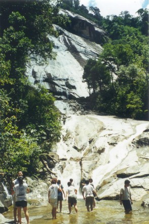
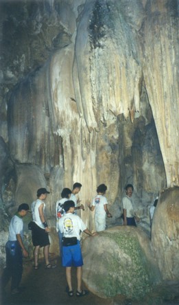
Jelawang waterfall or sometimes known as the Stong waterfall is one of the highest waterfalls in South East Asia and is found in the Gunung Stong State Forest Park. A trip to the Gunung Stong State Forest Park lets you experience an all rounded trek with caving, river and mountain treks. The 21,950 ha Gunung Stong State Forest Park is gazetted on 8 November 2007 with hill dipterocarp forest below 1000 m and upper dipterocarp forest and oak-laurel forest above that [1]. The Jelawang waterfall which stands over 300m high can be seen from a distance as you travel towards the park entrance. The nearest train station is Dabong train station. Before you proceed to the Jelawang waterfall make a trip to visit the limestone caves near the train station.
Caves near Dabong train station |
There are four popular caves near the train station, Gua Ikan, Gua Kris, Gua Pagar and Gua Gelap. These caves are open to public and they are relatively clean with few graffiti if any except Gua Ikan which is said to be badly vandalized. The cave system is interesting with some very narrow passageways and curious rock formations. Bats may also be found in some of the caves. Visiting the caves is very often part of the itinerary before moving on to the park head quarters.
The main attraction of Gunung Stong State Forest Park is the Jelawang waterfall. There are accommodation facilities at the base of the waterfall but most trekkers proceed to the Baha campsite that sits on top of the waterfall at an altitude of 450m. However, to reach there, you will need to trek for more than an hour up the side of the waterfall which is understandably steep and energy sapping. Upon reaching the campsite, most trekkers will rest and see out the remaining of the day in preparation for more treks on the following day. Baha campsite is conveniently situated near the river for your drinking and cooking needs. There is not much in terms of amenities at the campsite and the toilet is really just a hole in the ground. For experienced trekkers in Malaysia, this is definitely one of the better campsites for spending the night. Baha campsite is ideal as a basecamp for further treks.
The basecamp at Baha campsite is conveniently situated for climbing up to the summit of Gunung Stong and Gunung Ayam. The trek up to the summit of Gunung Ayam will take a full day and this typically requires a night to be spent on a campsite near its summit. As this campsite is well above 1000m above sea level, it can get quite cold at night. Depending on the speed and fitness of the team, one may proceed to Gunung Stong on the next day after coming down from Gunung Ayam or descend to Baha campsite for the night and take a return trip to Gunung Stong the following day.
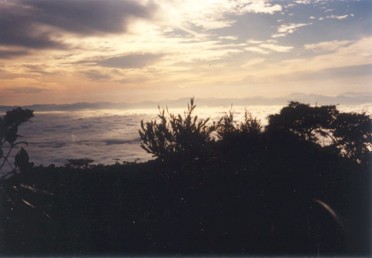
View near summit Gunung Ayam |
Back at the Baha campsite, you may trek further up-stream and be amazed by the rock formation carved by the running river. There are potholes to dip your full body in and smooth surface rocks for you to slide down to the pool below. Your guide will be able to point out where are the safer spots to have fun.
Apart from these common treks, the more adventurous can take on the seven summits challenge in the region. These seven summits are, Gunung Ayam, Gunung Stong, Gunung Tera, Gunung Che Kob, Gunung Che Tahir, Gunung Menyelit and Gunung Birut. It is estimated to take seven days to complete this trek.
Gunung Stong State Forest Park is one of the more interesting treks in Peninsula Malaysia with its high mountains and waterfalls. Although the facilities and accommodation at the base of the waterfall has not been well maintained, the Baha campsite is still good for those who came prepared for camping. The guides are good and are able to converse in English. As Gunung Stong State Forest Park is an extension of the Titiwangsa Range [1] and the trail to the mountains are not well marked, it is important to have a guide. Great care must also be taken at the Baha campsite especially those who wish to catch the sunrise at the top of the waterfall. There have been incidents of trekkers falling off the waterfall when they lost their footing on the rock surface.

|
Brief History
From the 1960s to 1980s, there are some logging and conversion of the land for agricultural activity under RPT and KESEDAR [3]. Although logging has completely stopped 1990s [3], its logging past can be seen at the lower land (below 1000m) where there are extensive areas of scrubland. In the early 1990s, Baha, a local guide start taking trekkers to the area and constructed basic huts at what is now known as Baha camp[3]. His team also found the current route that leads to Gunung Ayam and has named several other mountains in the region such as Gunung Baha [according to local guide], Che Kob, Che Tahir, Menyelit and Birut [3]. |

|
|

- The Quantum Singularity, 05 March 2010

Take train to Gua Musang. You may check out the train services, prices and dates on Malaysia Railway
To Gunung Stong State Forest Park [2]
| Cost of Boat ride across river | : | Rm 0.60 per person/trip |
| Cost of transport from across the river (Sungei Galas) to Gunung Stong State Forest Park entrance | : | Rm 2 per person/trip |
| Duration of drive to Gunung Stong State Forest Park entrance | : | 20 minutes |

| Duration (mins) | Description | Instructions | Remarks |
|---|---|---|---|
| 00 | Outside train station | Put bags in stores at train station and take a van to the cave | Remember to bring torch and water |
| 05 | Road side | Walk to the entrance of the cave led by the guide. | Vegetation can be quite thick |
| 10 | Cave entrance | Some part of the cave is so narrow that you have to crawl and squeeze through. | |
| 10 | Out of cave | Trek uphill | Limestone cave |
| 15 | Cave entrance | ||
| 08 | Big cave | ||
| 30 | Entered a small cave opening to reach another cave called Cage Cave (Pagar Cave). | ||
| 12 | Main road | Go down the road to Gua Ikan | Big signboard by the road |
| 04 | Water pool under Big stone | Relax and wait for van back to train station | |
| 05 | Train station |
Journey to Stong resort
| Duration (mins) | Description | Instructions | Remarks |
|---|---|---|---|
| 00 | Main road outside train station | Walk along main road straight ahead. | |
| 05 | Y-Junction | Turn left on Jalan Penjabat | |
| 02 | Y-Junction | Turn right on Jalan Penanbang | |
| 03 | Jetty | Take sampan across river | |
| 12 | Other side of river | Take van to Stong resort | |
| 20 | Reach Stong resort |
Trek to Basecamp
| Duration (mins) | Description | Instructions | Remarks |
|---|---|---|---|
| 00 | Beside waterfall | Steep ascent by side of river | |
| 13 | Reach main waterfall | ||
| 27 | Flat rock | Steep ascent | |
| 25 | Baha Jelawang Campsite (450m) |
Trek to Gunung Baha and Gunung Ayam
| Duration (mins) | Description | Instructions | Remarks |
|---|---|---|---|
| Day 1 | |||
| 00 | Jelawang campsite | Set off | |
| 43 | Sungei Rantai | Cross river. Have to climb up a steep part using a metal chain. | |
| 100 | Waterfall | Cross river | Lunch point |
| 160 | Gunung Baha summit (1309m) | ||
| 08 | Slow flowing stream | Last water point | |
| 20 | Gunung Ayam summit (1504m) | ||
| 10 | Campsite | ||
| Day 2 | |||
| 00 | Set off (Back trek) | ||
| 30 | Slow flowing stream | ||
| 20 | Gunung Baha summit | ||
| 100 | Waterfall | Cross river | |
| 100 | Sungei Rantai | Cross river | Lunch point |
| 55 | Jelawang campsite | ||
Trek to Gunung Stong
| From | To | Duration | Description |
|---|---|---|---|
| Junction of route to G. Baha/Ayam and G. Stong | Gunung Stong summit | 2 h | The junction is quite near the river on the way to G. Baha/Ayam |
Useful Timings (May 2003. Courtesy of The Mountain Trekker2)
| Starting point to Baha campsite summit | : approx. 1 hour |
| Baha campsite to Gunung Ayam summit | : approx. 5.5 h |

Trip to caves near Dabong train station
Proceed to park entrance and trek up to Baha campsite
Day 2:
Have breakfast and break camp. Depart campsite by 8 am
Trek to the summit of Gunung Ayam
Day 3:
Have breakfast and break camp. Depart campsite by 8 am
Trek to down from the summit of Gunung Ayam
Leave behind camping gears at a junction and proceed to Gunung Stong
Return from summit of Gunung Stong, pick up camping gears and return to Baha campsite
Day 4:
Have breakfast and have some fun at the river further upstream
Break camp and depart from Gunung Stong State Forest Park

| Gunung Stong State Forest Park (Forestry Department) entrance fee | : | Rm 5 [ref. 3] |
| Stong Resort entrance fee | : | Rm 2 [ref. 3] |
| Campsite fee per night (Baha campsite) | : | Rm 3 [ref. 2,3] |
| Guide fee per day for climb to mountain (as of Sep 2001) | : | Rm 90 per guide [ref. 3] |

Contact number: 019-959-1020
Email: batgssp@yahoo.com

- Outdoors Sandals
- Light weight clothes
- Tent
- Groundsheet
- Gas stove and canister
- Lamp/torch
- Pots for cooking/ Mess Tin
- Small Shovel
- Nylon string
- Water Purification Tablets
- First Aid Kit
- Toiletries
- Toilet Paper
- Extra clothing
- Kitchen utensils (Fork, Spoon)
- Rain gear
- Sleeping bag
- Cap/Hat
- Windbreaker/Jacket
- Lighter
- Swiss Knife
- Insect repellent
- Water container


| Date | Description | Source |
|---|---|---|
| 30 December 2013 | A 23-year-old undergraduate from National University of Singapore (NUS) has died after falling into a waterfall last Saturday, while on a trekking trip in Kelantan, Malaysia. | TODAY |
- WWF Gunung Stong State Park. [17 May 2015]
- TheMttrekker - Gunung Stong, Gunung Baha and Gunung Ayam [17 May 2015]
- Gunung Stong State Forest Park:A Guidebook, Edition 2009 [17 May 2015]