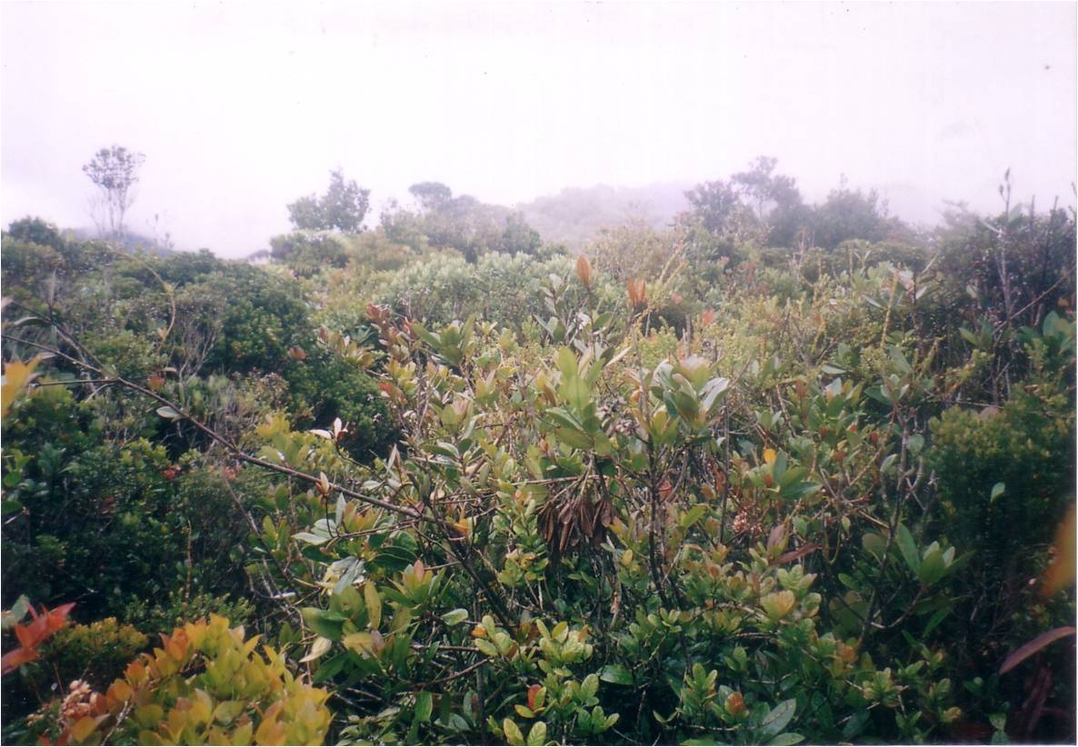
View from summit of Gunung Ulu Sepat, April 2001. |
| Location | Perak-Kelantan, Malaysia |
|---|---|
| Height | 2161 m |
| Terrain | Mixed forest trail |
| Recommended duration | 3 days, 2 nights (Temenggor Dam) |
| Ease of access | 4-wheel drive to Orang Asli village |
| Special equipment | None |
| Good | Trek through mossy forest. Untamed forest. |
| Not so good | Expect sandflies at the campsites. Restricted view from the summit. |
Most of the mountains reaching a height of more than two thousand meters in Peninsula Malaysia are found along the main range, also known as the Titiwangsa range. Treks along the higher altitude here are characterized by the mossy forest which thrives in cool and damp environment. Such an environment is formed by moisture laden clouds being pushed up by the mountain range. At the same time, this also results in frequent precipitation (rain). Gunung Ulu Sepat, the 7th highest mountain in Peninsula Malaysia with its summit at a elevation of 2161 m is also found along the Titiwangsa range.
This trek brings you through primary rainforests that are rarely visited. The Titiwangsa range consists of hundreds of kilometers of primary rainforests where any lost trekker may never be found. An expedition to Ulu Sepat often involves engaging the service of local Orang Asli who knows the terrain well and is able to identify the seldom used trails up the mountain. Wild elephants live in this forests and their presence can be seen from the fresh dung that they deposit on the trails along the ridgeline. Huge trees untouched by loggers still dominate the lowlands along the northern-western route although logging activities are still active in parts of the south-eastern route.

Heavily eroded road along the southeast route, April 2001. |
There are a few approaches to the summit of this mountain. The most commonly used route is from the northwest through Temenggor Dam. However, it is also possible to approach from the southeast. The northwest route is shorter and takes about three days to complete while the southeast route takes 4 full days1. Either approach requires taking 4-wheel drive to get to the starting point deep in the forest where the road is just dirt tracks. The northwest approach is by far a much easier route compare to the southeast route. The first day of trek is to an Orang Asli settlement. The second day is to the summit and back with a daypack. This probably makes Gunung Ulu Sepat one of the easier treks on Titiwangsa range. A south-eastern approach was attempted in 2001 led by Mr Forest Gan and some local Orang Asli1. It was a new path with the Orang Asli clearing the trail and setting up a campsite beside a stream in the forest. The path cuts across several ridges before finally ascending the ridgeline that led to the summit of Gunung Ulu Sepat.
Most treks to the mountains on Titiwangsa range are not recommended for novice due to the steep ascent and long trekking days. For Gunung Ulu Sepat, the summit is covered with dense vegetation that blocks the view and misty often restricts view to less than a hundred meters. The approach is interesting and you have the sense that this is a wild and untamed forest. Apart from the unmistakable sight of elephant dung and footprints, your guide may also point out paw-prints of tigers that still live in this forest.
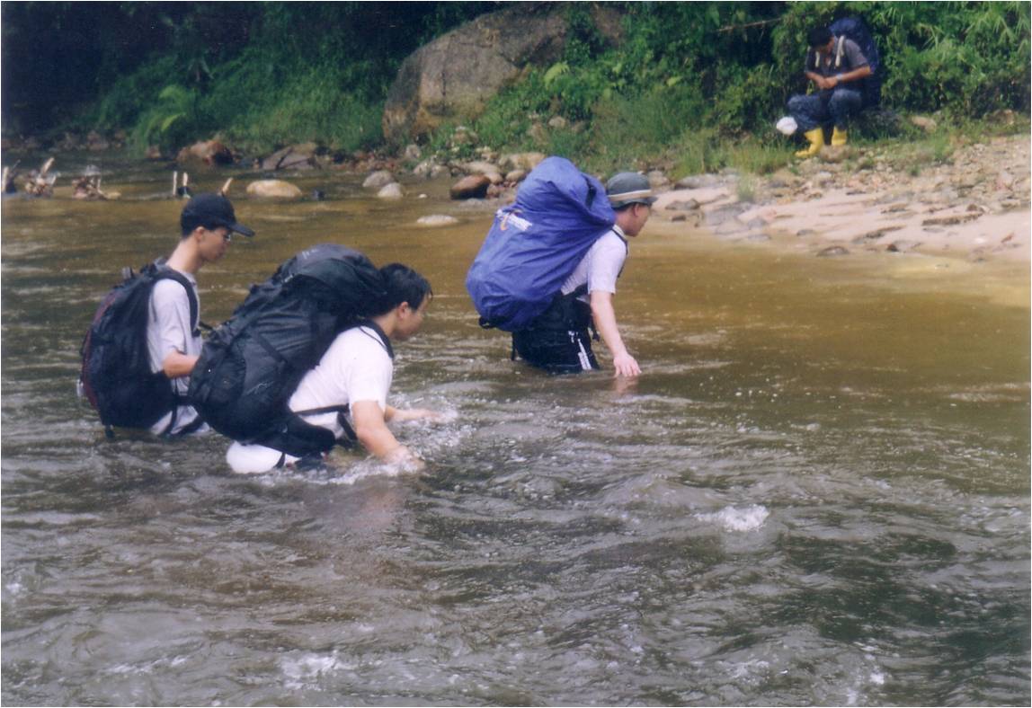
River crossing on the southeast route, April 2001. |

- Collin Traveller, 04 September 2011.
- Lonely Jungle of Malaysia, 18 April 2012.
|
Blog post, from The MtTrekker
27 April 2001 Ulu Sepat, standing at 2161m, is 7th highest mountain in Peninsula Malaysia. According to our guide, Forest Gan, we would be taking a new route for this trip. It certainly seemed to be the case as the Orang Asli guides were creating new trail as we trek towards the summit. Located in the Titiwangsa (main) range, it receives a significant volume of rainfall annually. On this trek, it rained daily especially in the late afternoon. The starting point for our trek was near Gua Musang. From there, it was a 4hrs ride by 4-wheel drive to the starting point at a Orang Asli village located deep in the mountains. Most part of the ride through the mountains was on logging trails which were well-maintained as logging were still carrying out in the region. However, once the vehicle entered the trails which were no longer in use, the road condition deteriorated. In fact, the vehicles were stuck in the mud on one occasion and we had to push it free. At the Orang Asli village, we could see that they seldom have visitors as the children look at us with great curiosity. It was also at this village where Forest Gan engaged two Orang Aslis as guides to bring us to the mountain. The trek was certainly challenging and full of surprises. About 2 hours into the trek, we have to cross a wide river where the water level reached our waist level. For one-third of the trek, we were walking on old logging trail. Part of the logging trail has been abandoned for so long that erosion formed deep gullies on it. As we trekked deeper into the mountains, the Orang Asli guides traverse across ridges where there were rivers and streams at the bottom of the ridge. However, that also meant there were a lot of ascent and descent. As this was a new trail, there were really no trails to follow at all towards the last third of the journey in the forest. The Orang Asli guides have to use parangs to hack their way through the thick vegetations. Despite walking and clearing a path, they were still moving at a faster pace than us. During our descend down the mountain, we lost sight of them and have to rely on following the trail of chopped plants to lead us to the campsite. Probably due to the high rainfall, the vegetation at the summit of Ulu Sepat was very thick and reached up to head level which blocked out any view. Moreover, there was a complete white-out as the clouds moved in and a light drizzle. A point of interest was there were evidences of heavy elephant traffics nearer to the summit of this mountain. Elephant dung were everywhere along the trail and some looked fresh. Near to thee summit, the trail was very muddy, probably elephant dung mix with water. Ulu Sepat, like many other mountains found in Titiwangsa range is not meant for the novice to Peninsula Malaysia mountains. Good fitness level and mental strength is required to tackle the mountain as not only are we required to carry heavy loads and make long, tiring treks, the daily rain and sandflies at the campsites would make life quite miserable. However, there are certainly some personal satisfactions and valuable experience gained from such a trek. One thing for sure, trekking through virgin forest, making new path and experiencing the isolation of the region are something that very few treks can offer. |

Boat ride from Temenggor Dam jetty followed by 4WD ride to Orang Asli village. Start trek.
Day 2:
Trek to summit with day pack and return to camp.
Day 3:
Leave campsite for civilization
Source: Lonely Jungle of Malaysia, 18 April 2012.

- Outdoors Sandals
- Light weight clothes
- Tent
- Groundsheet
- Gas stove and canister
- Lamp/torch
- Pots for cooking/ Mess Tin
- Small Shovel
- Nylon string
- Water Purification Tablets
- First Aid Kit
- Toiletries
- Toilet Paper
- Extra clothing
- Kitchen utensils (Fork, Spoon)
- Rain gear
- Sleeping bag
- Cap/Hat
- Windbreaker/Jacket
- Lighter
- Swiss Knife
- Insect repellent
- Water container

- The Mountain Trekker - Gunung Ulu Sepat, [30 April 2015]