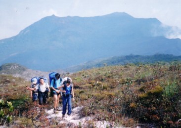
Summit of Gunung Tahan is the highest point on the right. |
| Location | Kelatan-Pahang, Malaysia |
|---|---|
| Height | 2817 m |
| Terrain | Forest trails, sub-alpine trail, river treks, rope obstacles |
| Recommended duration | 5 days minimum (Merapoh to Kuala Tahan) |
| Ease of access | Taxi/cab to Sungei Relau Park Entrance |
| Special equipment | None |
| Good | Wide variety of terrains, unobstructed view of mountain range |
| Not so good | Bees at campsites, leeches along Kuala Tahan route, challenging trek |
Trek with magnificent views, experiencing all the terrains encountered in a forest treks and top it off with a view of the sunrise at the highest peak of peninsular Malaysia. Gunung Tahan is possibly the best and one of the toughest treks in peninsular Malaysia. Gunung Tahan is located within the Taman Negara National Park, the largest national park in peninsular Malaysia and stands at the border of Kelantan and Pahang. Larger wild life such as elephants and tigers still inhabits this primary forest.
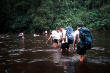
One of many river crossings on the Gunung Tahan trek. |
Multiple river crossings, rope obstacles, highland ridgeline trek, physical and mental endurance are all found and experienced on this trek. Traditionally, this trek starts and ends at Kuala Tahan and will take on average six days to complete and is a real test on human endurance. With the opening of a route from Sungei Relau, it is possible to reach the summit on the second day of the trek. While it is possible to return via the same route, it is highly recommended to proceed down via Kuala Tahan route which is a 3 days trek to have a complete experience of the expedition. The view along Gunung Tahan trek is amazing and contrasts that of the main (Titiwangsa) range although their altitude is almost the same. While thick, tall bushes blocks any view on the mountains along Titiwangsa range, the vegetation on Gunung Tahan is markedly different and comprises of short shrubs at the higher altitude.
"Tahan" means "Endure" in Malay and as the name suggests, is not an easy trek. It usually takes a physically fit person 2 days to ascend from Sungei Relau and 3 days to descend to Kuala Tahan. Most trekkers hire a guide and carry all the necessary food and gears on their backpack. Individual load of more than 15 kg can be expected for the five days trek. Sufficient training in preparation for the physical demand of this trek is necessary. In year 2000, a group of 13 trekkers have to wait in the forest for 4 days before rescuers bring an injured trekker off the mountain. Mental strength is also tested on this trip as there are numerous river crossings and most trekkers go through these with their socks and boots on and this means walking with wet socks and boots throughout the journey. Leeches are also common on the trek via Kuala Tahan so be prepared to lose some blood. Given the physical and mental challenge of Gunung Tahan, to have completed Gunung Tahan trek is recognition of one's trekking endurance and strength.
Sungai Relau is approximately 7km from the small town of Merapoh, which is at the halfway point along the main road from Kuala Lumpur to Kota Bharu, Kelantan. The nearest towns are Gua Musang (30km) and Kuala Lipis (100km). The park ensures the trek remains clean by having stringent checks and count of the items brought up the mountain. These will be cross-checked at the end of the trek. A guide is compulsory for safety reason and also to ensure that the park rules are followed. Towards the end of the second day of trek, you will encounter vegetation comprises mainly of short bushes and shrubs that barely reach your waist level. This gives an amazing unobstructed view of the surrounding hills and mountain ranges and the path ahead. However, you will need to navigate through muddy trails and elephant dungs when the trek reaches higher elevation.
You may spend the night at camp Botak which has water available or continue for an hour of continuous uphill trek to the summit where there is another campsite. However, drinking and cooking water needs to be carried up to the summit camp as there is only a stagnant pool of water near that campsite. The summit camp is less than a fifty meters walk on a flat ground to the summit which is marked by a prominent signpost. Catch the sunrise at the summit and start an early descent down Gunung Tahan. The terrain is relatively gentle and is surrounded by short shrubs for the next 4 to 5 hours of trek until you have reached Gunung Gedong.
From there, it is a steep decent to the forest trees with ropes to help the climb down. The rest of the day is spent trekking along the ridgeline with a few peaks that require ropes to cross over until you have reached Wray's camp. This is a small campsite and the water source is about 5 minutes of downhill trek. The trek from here to the next campsite is a gentle downhill walk along forest trail. If you are able to reach Wray's camp for lunch, you may wish to consider continue down to the next campsite at Kuala Teku which is beside a river. However, this journey will take close to 4 hours or more and the team has to be confident of reaching the campsite before night falls. From Kuala Teku to the next campsite at Kuala Puteh takes about 5 to 6 hours with multiple river crossings. Most teams spend the night at Kuala Puteh before taking on Gunung Rajah and the 27 hills of Bukit Malang. After overcoming Gunung Rajah and Bukit Malang, some teams may choose to spend one more night at Kuala Malantai. Otherwise, it is a relatively simple trek linking to park trails that leads to the resort of Kuala Tahan.
|
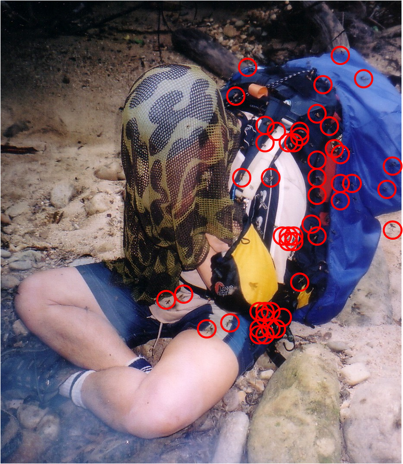
Sweat Bees of Kuala Tahan A common sight at the campsites along Kuala Tahan is the sweat bees. These bees are given this name because they are attracted to the sweat on trekkers and are mostly about 3 cm long. It is common to see a few bees resting on your clothes that are hung up to dry at any one time. They generally do not sting but can be quite hair-raising as they rest on your clothing and hands to lap up the perspiration. Do not try to swap them in case they turn aggressive. According to local guides, there will be a bee population explosion every decade. During that year, hundreds of bees will swarm the campsite. Getting a few stings are inevitable as they sometimes crawl between you and your backpack. Fortunately, they will go away when the night falls. You may also wish to stay away from the campsite until night falls.
|
|
| Trivia
The name, Wray's camp, comes from Messrs Wray, a member of the 1905 Robinson team, who had to rest on the camp due to diarrhea and evacuated from the mountain without making to the summit of Gunung Tahan3. |

|
Brief History of Gunung Tahan
Gunung Tahan is known by various names in up till the early 1900s. On the western side of the mountain, it is known as Gunung Rotan (that side of the mountain is filled with rattan which was a valuable resource) or Gunung Ulu Tanum, northern side of the mountain, it is known as Gunung Siam, while the name, Gunung Tahan comes from the southern area of Pahang. In the past, local folklore is that the peak of Gunung Tahan had two wells guarded by giant cannibal apes which contained magic stones that were able to change objects into gold and silver. Giant creatures such as mosquitoes as large as fowl, gigantic serpents and spirits were also thought to inhabit the area around Gunung Tahan. This had prevented most locals from climbing to the peak of Tahan although two unsuccessful expeditions were sent by the Sultan Ahmad of Pahang to search for the magic stones in 1880s. The first recorded successful summit bid is by Herbert C. Robinson, Che Nik, Mu'min, Mat Aris and Bulang at 10:15 a.m on July 16, 1905. The 65-man expedition team comprising mainly of local Malays took nearly two months after leaving Kuala Tahan to reach the summit. This was after numerous unsuccessful attempts in the 1890s by the Europeans. Local gatherers might have reached the summit of Gunung Tahan before Robinson in 1905 but there are no records of it. Source: Yaakob S S N and Amri S. Journal of Wildlife and Parks 2009-2010; 26: 953. |

Verified on November 2014

- Of Travel and Photography, 13 April 2013.
- Trekking Noob, 27 January 2012.
- Malaysia Trekking, 03 January 2007.

Take train to Gua Musang. You may check out the train services, prices and dates on Malaysia Railway
To Park Office at Sungei Relau
Via Private vehicle 2:
| Cost of 4-wheel drive (4WD) | : | Rm 10 per person |
| Duration | : | 40 min |
| Remarks | : |
Check with local restaurant/food stall owner if they know of any driver providing transport service Negotiate price with driver on the spot. |
From Sungai Relau to Kuala Juram (Starting point of trek)
Via park vehicle: Rm 24.00 per person for two(2) way journey1.

| From | To | Duration | Height | Remarks |
| Kuala Juram | Kem Kor 2 | 4hr | 750m | Cross 4 rivers;At Kem Kor 2: Suitable campsite; water available |
| Kem Kor 2 | Kubang | 3hr | 1406m | Walk mainly along ridgeline; At Kubang:Water available; Suitable campsite |
| Kubang | Belumut | 35min | 1493m | Muddy trail |
| Belumut | Bonsai | 3hr | 1705m | Muddy trail |
| Bonsai | Botak | 70min | 1904m | At Botak:Water available; Suitable campsite |
| Botak | Summit | 1hr | 2187m | At summit:Water available for washing but not for drinking; Suitable campsite |
| Summit | Gunung Gedong | 4hr | 2066m | Cross a saddle; Water available after about 2.5hr; Small spring pool, may not be reliable |
| Gunung Gedong | Gunung Reskit | 1.5hr | 1666m | Steep descend |
| Gunung Reskit | Gunung Pankin | 3hr | 1462m | Walk on ridgeline with 3 to 4 steep up and down slopes that requires rope. |
| Gunung Pankin | Wray's camp | 1hr | At Wray's camp:Water source 5min descend on trail to the left side of main trail | |
| Wray's camp | Kuala Teku | 3.5hr | 168m | At Kuala Teku:Water available; Suitable campsite; A lot of bees |
| Kuala Teku | Kuala Puteh | 5.5hr | 122m | 9 river crossings; If water level too high, guide might bypass some of them; Beware of leeches along the way;At Kuala PutehWater available; Suitable campsite; Bees are present |
| Kuala Puteh | Gunung Rajah | 2hr | 575m | |
| Gunung Rajah | Kem Tengah | 1hr | 379m | Water source 10 min, descend on trail to the left side of main trail |
| Kem Tengah | Kuala Melantai | 4hr | Bukit Malang(27 hills);At Kuala Melantai:Water available; Suitable campsite | |
| Kuala Melantai | Resort at Kuala Tahan | 5hr | Cross a hill before reaching flat ground. Muddy trails |
The above timings vary from individual fitness to size of group. It should only be used as a very rough guide.
June 2002. Courtesy of The Mountain Trekker2

Day 1:
Report at Sungei Relau by 9 am.
Registration, checking of gears and briefing by guide
4WD to Kuala Juram
Start trek. Camp at Kem Kor 2.
Trek duration: 4 hours
Day 2: Start trek at 8 am
Camp at summit campsite
Trek duration: 8.5 hours
Day 3: Start trek at 8 am
Camp at Wray's camp
Trek duration: 9.5 hours
Day 4: Start trek at 8 am
Camp at Kuala Puteh
Trek duration: 8.5 hours
Day 5: Start trek at 7 am
Stay overnight at Resort in Kuala Tahan
Trek duration: 12 hours
Note. This itinerary is meant for a team with good fitness.

| Entrance permit | : Rm1.00 per person |
| Camera Licence | : Rm5.00 per person |
Campsite Fees
RM 1.00 per person per night
Guide Fee
| Route and duration | Fees (RM) per guide |
|---|---|
| Kuala Tahan - Gunung Tahan (summit) - Kuala Tahan (7 days, 6 nights) | 1200 |
| Kuala Tahan - Gunung Tahan (summit) - Kuala Juram (Merapoh) (7 days, 6 nights) | 1200 |
| Kuala Tahan - Waterfall - Gunung Tahan (summit) - Kuala Tahan (9 days, 8 nights) | 1400 |
| Kuala Tahan - Waterfall - Gunung Tahan (summit) - Kuala Juram (Merapoh) (9 days, 8 nights) | 1400 |
| Kuala Juram (Merapoh) - Gunung Tahan (summit) - Waterfall - Kuala Tahan (9 days, 8 nights) | 1400 |
| Kuala Juram (Merapoh - Gunung Tahan (summit) - Kuala Juram (Merapoh) (5 days, 4 nights) | 950 |
| Kuala Juram (Merapoh - Gunung Tahan (summit) - Kuala Tahan (7 days, 6 nights) | 1200 |
| Charges for extra day | 150 per day |
Number of climbers is limited to 12 people per guide
Number of climbers is limited to 48 people per day
Only registered guides are allowed
Contact Information
Deputy Superintendent,
Pahang National Park,
Sungai Relau, Merapoh
27210 Kuala Lipis, Pahang
Tel/ Faxs: 09-915 0214
Email: tnsgrelau@wildlife.gov.my; mzulfadli@wildlife.gov.my
Source: Department of Wildlife and National Parks Peninsular Malaysia1

- Outdoors Sandals
- Light weight clothes
- Tent
- Groundsheet
- Gas stove and canister
- Lamp/torch
- Pots for cooking/ Mess Tin
- Small Shovel
- Nylon string (for hanging clothes)
- Water Purification Tablets
- First Aid Kit
- Toiletries (Toothpaste, toothbrush, talcum powder, no-rinse shampoo)
- Toilet Paper and wet wipes
- Extra clothes
- Kitchen utensils (Fork, Spoon)
- Rain gear
- Sleeping bag
- Foam/inflatable sleeping mat
- Cap/Hat
- Windbreaker/Jacket
- Lighter
- Swiss Knife
- Insect repellent
- Water container(s) for 3L of water
- Leech repellent (eg. Vinegar solution, salt)


| Date | Description | Source |
|---|---|---|
| 08 Feb 2016 | A 43-year-old Singaporean drowned after he was swept away in Sungai Kuala Luis near Merapoh while hiking up Gunung Tahan. | New Straits Times via Yahoo News |
| 14 Feb 2013 | A 35 year old climber was reported dead after suffering from chest pain and shortness of breath in an expedition to Mount Tahan. | Berita TV3 |
| 29 July 2000 | 13 British tourists were stranded on Gunung Tahan after a 16 years old Briton slipped, fallen and dislocated his right shoulder during the downhill climb near Gunung Pangkih. | The Straits Times |
- Department of Wildlife and National Parks Peninsular Malaysia
- The Mountain Trekker - Gunung Tahan
- Yaakob S S N and Amri S. Gunung Tahan Trail: Some History and Background. Journal of Wildlife and Parks 2009-2010; 26: 95. Free Access