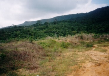
Gunung Panti. The summit is the peak on the left. |
| Location | Kota Tinggi, Malaysia |
|---|---|
| Height | 531 m |
| Terrain | Forest trail |
| Recommended duration | 2 days, 1 night |
| Ease of access | Cab to the starting point of trek |
| Special equipment | None |
| Good | Relatively clean. |
| Not so good | No drinking or cooking water at the campsite. Leech at the lower part of the hill. |
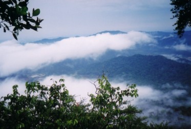
Morning view from the summit of Gunung Panti. |
Spend the weekend at the "garden" on the plateau of Gunung Panti. Gunung Panti is located near Kota Tinggi town and is easily identifiable by its plateau. Despite having a height of just over 500 m, morning mists can be seen rising from the forests below in the early morning on the summit of Gunung Panti. The big rainforest trees on the lower half of the hill gives way to shorter shrubs, palms and smaller trees which is able to survive on the rocky steep section of the hill and the summit. Luminous fungi can be found around undisturbed perimeters of the campsite although they can be quite faint and difficult to spot.
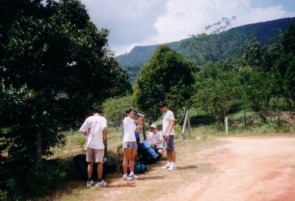
Starting point of trek in Kumpong Lukut. |
The trail from Kampong Lukut is less frequently used to reach the summit of Gunung Panti compared to the forest trail. It is much less technically challenging as there is no rock face to overcome but the trail may be less obvious. This route leads up to the eastern side of the plateau and it is a nice traverse to the western side which marks the true summit. The starting part of the trek is in a fruit plantation. However, after a few minutes of trek, the trail leads into vegetated area although tree cover is still quite sparse and it can get quite hot under the sun. After about half an hour of trek, the trail leads into the forest. Leeches can be quite common at this lower part of the hill. Nearer to the top of the plateau, the trail gets steeper as you trek up the plateau face. About twenty minutes of trekking on the plateau will bring you to the first campsite. There is a gully at the campsite which traps rain water. The true summit is another thirty minutes of trek where there may be some muddy sections to navigate across.
Gunung Panti is more than just a hill for avid trekkers who are looking for a weekend getaway. It is also frequent by bird watchers1 and is also known for its diversity of plants and animal species2. There is even a lizard that is named after it, Gunung Panti Bent-toed Gecko ( Cyrtodactylus pantiensis )3. It has also been reported that fossilized ancient plants from the Jurassic and Cretaceous period has been discovered on the Gunung Panti. While a trip to Gunung Panti can be completed within a day, it may be worth extending it to a two days one night trip to enjoy what nature has to offer. You may even chance upon a fossilized dinosaur.
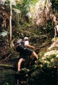
Gunung Panti via lukut, start of steep ascend |

Take a bus to Kota Tinggi bus terminal. You may check out the available bus services, prices and dates on http://www.busonlineticket.com
From Kota Tinggi to Lukut
Via taxi (March 2003)5:
Tell the driver that you are going to Gunung Panti via Lukut.
Cost: Approx. Rm 10 to 15 per taxi (one way)
Duration: 20 min Remarks: You may ask the driver to come back to pick you up for the journey back or go down via the forest route.

| Duration(mins) | Description | Instructions | Remarks |
| 00 | Plantation at the end of the road | ||
| 05 | T-junction | Turn right | |
| 03 | Wooden gate | Cross the wooden gate | |
| 05 | Y-junction | Turn left | |
| 02 | Stream | Cross stream | |
| 13 | T-Junction | Go straight | This junction is not obvious |
| 02 | Y-Junction | Turn right | Uphill slope at the right side of the trail. Signboard at the opposite side of the route saying "Ke Gunung Panti" |
| 20 | Big rock | Trail continues behind the rock | |
| 05 | Trail leads to the right | Start of steep ascend | |
| 15 | T-Junction on top of plateau | To summit, go straight.Turn left to see view of the southern part of Johor; | End of steep ascend |
| 06 | Y-Junction [Sign board]"Ke Tapak Perkemahan" | Turn left | |
| 04 | T-Junction | Turn left | |
| 10 | Campsite | Go straight | Unreliable water source. Stagnant pool. |
| 30 | Summit, campsite |
Information courtesy of The MtTrekker5

Have lunch at Kota Tinggi town. Start the trek at about 2 pm
Set up tent at campsite prepare dinner
Rest for the night
Day 2:
Have breakfast and break camp. Depart campsite by 8 am
Reach main road and take bus to Kota Tinggi town for lunch.

- Outdoors Sandals
- Light weight clothes
- Tent
- Groundsheet
- Gas stove and canister
- Lamp/torch
- Pots for cooking/ Mess Tin
- Small Shovel
- Water Purification Tablets
- First Aid Kit
- Toiletries
- Toilet Paper
- Extra clothing
- Kitchen utensils (Fork, Spoon)
- Rain gear
- Sleeping bag
- Cap/Hat
- Windbreaker/Jacket
- Lighter
- Swiss Knife
- Leech repellent
- Water for drinking and cooking

- Lim K S, Yong D L, Lum W W, Lim K C. Birding the tip of the Malay peninsula: bird diversity and birding sites in Johor. BirdingASIA 2012; 17: 81.
- Li Y D. Preliminary List of Larger Vertebrates in the Panti Forest Reserve, South Johore (2002-2006). http://wildbirdsingapore.nss.org.sg/Store/Panti%20Vertebrate%20List.pdf. [04 Dec 2014]
- Panti Bent-toed Gecko. Ecology Asia. http://www.ecologyasia.com/verts/lizards/panti-bent-toed-gecko.htm. [04 Dec 2014]
- Dinosaurs may have roamed in Malaysia millions of years ago - Central - New Straits Times. 28 January 2014. Read here.
- The Mountain Trekker - Gunung Panti via Lukut