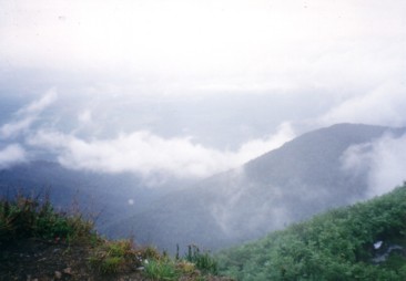
Gunung Ledang summit view, November 2001 |
| Location | Johor-Malacca, Malaysia |
|---|---|
| Height | 1276 m |
| Terrain | Mixed forest trail, rock obstacles. |
| Recommended duration | Day trek |
| Ease of access | Cab to the park entrance or walk 2km from main road. |
| Special equipment | None |
| Good | Excellent view from summit. |
| Not so good | Crowded. Expensive. |
Scale the highest mountain in the state of Johor and enjoy a 360° unobstructed view from its summit. Gunung Ledang is probably the most popular mountain for trekking in Peninsula Malaysia. There are three trekking routes to reach the summit of Gunung Ledang of which the Sagil route is the most commonly used. This route comprises of a mixture of tropical rainforest, rock obstacles and cliff face. Asahan route is slightly shorter than the Sagil route but it is seldom used. Ulu Jementah trail is the longest route and it takes two full days to reach the summit of Gunung Ledang. Very few people attempted this route due to its duration and not much information is available. There have been a few changes to the Sagil route since 2008 with the Lagenda trail replacing the earlier Ayer Panas trail. Only the initial part of the trail is being affected and the path converges just before the KFC (Killer for Climbers), so named for its continuous steep uphill trek.
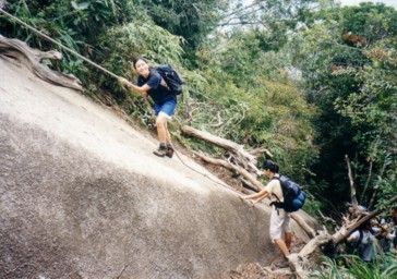
Scaling a steep slope with the help of a fixed rope before Bukit Botak, November 2001 |
The Sagil route is interesting due to its mixed terrain. Initial part of the trek is quite simple with man-made stairs before giving way to forest path. At the end of the KFC, this is where the trek becomes more interesting and the first obstacles are huge rock boulders. Ropes and ladders have been installed to help trekkers climb overcome them. Soon, there are rock faces a few storeys high which you will need to use the fixed ropes to climb up. After scaling the rock faces, you will reach the top of Bukit Botak, so named for its patches of barren land. This used to be a campsite but it is probably not used due to rumors of lightening striking on the tents. There is a small water source a short distance away from Bukit Botak and this is the last water source. After descending from Bukit Batok, it is a steep ascend that ends with a series of ladders that leads to the summit. There are no trees on the summit and it can get very hot under the sun. On a clear day, the view from the summit is awesome but on some days, the summit may be shrouded in mists or clouds may block the view.
Gunung Ledang is probably boasts the best trek with the best view in the state of Johor. At a height of more than a thousand meters, reaching its summit will give you a sense of achievement. The only drawback is its cost. However, this is necessary to ensure that the cleanliness of the trail can be maintained. Apart from that, it should be near the top of the list of mountain in Peninsula Malaysia to go to.

|
|

- Adventure Vacation Trip, 28 July 2012.
- MyTripJournal, 26 August 2011.
- Grace Abundant, 02 October 2012.

Take a bus to Segamat Express bus terminal. You may check out the available bus services, prices and dates on http://www.busonlineticket.com
To Sagil
Via Bus:
| Bus company | : | KKKL Express bus1 |
| Cost | : | Rm 5 |
| Duration | : | about 3 hours |
| Remarks | : | Check at booth. Inform the driver that you are going to Gunung Ledang. The bus only stops at the main road. |
| Public bus from Segamat bus station to Sagil3 | ||
| Cost | : | Rm 2.50 |
| Duration | : | 50 minutes to 1 hour |
| Frequency | : | 30 minutes |
Walk to Gunung Ledang Resort from main road.See map below
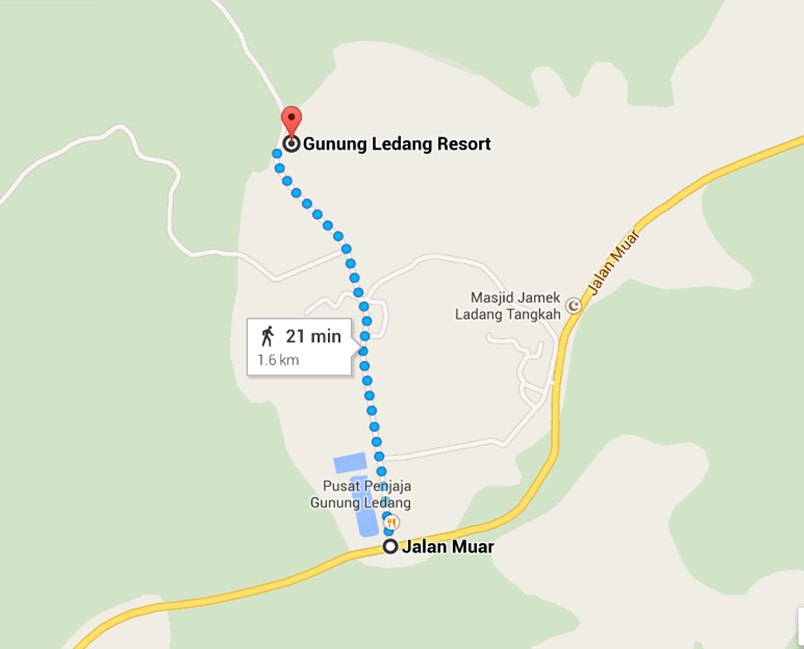
<Click on map to go to google map>
| Duration (mins) | Description |
|---|---|
| 00 | Starting point. Steps and muddy trail to CP2 |
| 15 | CP1. Steep and muddy trail to CP2 and CP3 |
| 30 | CP3. Relatively gentle gradient to CP5 |
| 50 | CP5. Small stream. Steep muddy trail and some rock obstacles to CP6 |
| 35 | CP6. Huge boulders and cliff face requiring the use of ropes to climb to reach CP7. |
| 60 | CP7. Bukit Botak. Descend before climbing up to summit using ladders. |
| 30 | Summit |
MyTripJournal, 26 Aug 20111
Grace Abundant, 02 October 20122
Useful Timings
| Starting point to summit | : approx. 3 hours 40 minutes |

| Entry charge | : | Rm 10 for foreigners Rm 5 for Malaysians |
| Hiking fee | : | Rm 10 |
| Insurance charge | : | Rm 2 per person |
| Guide fees | : | Rm 140 |
| Refundable rubbish deposit | : | Rm 20 |

- Light weight clothes
- Lamp/torch
- Water Purification Tablets
- First Aid Kit
- Extra clothing
- Rain gear
- Windbreaker/Jacket
- Swiss Knife
- Insect repellent
- Water for the trek

- MyTripJournal [10 Dec 2014]
- Grace Abundant [10 Dec 2014]
- Gunung Ledang (Mt Ophir) [10 Dec 2014]