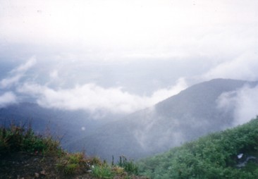
Gunung Ledang summit view, November 2001 |
| Location | Johor-Malacca, Malaysia |
|---|---|
| Height | 1276 m |
| Terrain | Mixed forest trail, rock obstacles. |
| Recommended duration | 2 days, 1 night |
| Ease of access | Cab to the park entrance |
| Special equipment | None |
| Good | Less crowded than Sagil route. Excellent view from summit. |
| Not so good | Long monotonous forest trek before rock obstacles. Expensive. |
Take a route less travelled to the summit of Gunung Ledang, start your trek from the Asahan village which is located at the north-western side of the mountain. Gunung Ledang is the highest mountain in the state of Johor. It has a 360° unobstructed view of the surrounding landscape from the summit and is a popular mountain for both Malaysians and Singaporeans. With less visitors coming by the Asahan route, the trail is less eroded and cleaner than the popular Sagil route.
The Asahan route is a more direct, uphill trek to the summit of Gunung Ledang. Due to less human traffic, you may experience more wild life and hear the gibbons calling in the early morning. The trek can be quite monotonous as you ascend through the tropical forest for nearly three hours before reaching the first rock obstacle. After getting up the rock face, there is a campsite with a stream beside. From this campsite, it is another one and a half hour trek to the summit. At a height of over 1000 m, you can see clouds below in the early morning. But if you are unlucky, the summit will be covered by the clouds hiding any view from the top.
A drawback for this trek is its cost. The trail to the summit is obvious but a guide is compulsory. There are also other charges such as insurance and an entry fee of Rm 10 per person (foreigner). A certain level of fitness is recommended as it takes more than four hours of uphill trek to reach the summit. There are also some technical sections in the form of rock face which makes the climb more interesting but risky. These are not overly technical and most people will be able to overcome them.
For those who have climbed Gunung Ledang from Sagil and wish to revisit the mountain, the Asahan route offers fresh approach. If you are able to start the trek early, it is possible to hit the summit for lunch and return to the starting point within a day.

|
|

- Bijhar Singapore, 30 May 2014.
- KZhang - Mystical Gunung Ledang, 04 July 2010.

Take a bus to Tangkak bus terminal. You may check out the available bus services, prices and dates on http://www.easybook.com/bus-company/cepat-and-cekap-bus.aspx
To Asahan village
Via Cab:
Inform the driver that you are going to Lubuk Kedondong waterworks at Asahan village1.
Estimated cabfare: Rm 30 to 40 per cab2
Self-Driving1:
- Drive to Tangkak
- Take road no. J123 to Simpang Bekoh
- Turn right at the second junction following the road signboard to Asahan
- At Asahan, look for Laman Tiga Budaya Asahan.
- When you see the Gunung Ledang (Asahan) Registration Post, turn right into the dirt road where there is a carpark

| Duration (mins) | Description | Instructions | Remarks |
|---|---|---|---|
| 00 | Signboard "Hutan Simpang Gunung Ledang" | ||
| 50 | Signboard "GLC 2" | Along the way, there will be arrows, "GLC", pointing towards the direction of travel | |
| 50 | Signboard "GLC 3" | ||
| 60 | Rock face | There is a small path on the left side of the rock face. | |
| 10 | Sign board "GLC 4" | Turn right to campsite. Stream on right side of campsite facing the summit | Path to summit is behind signboard |
| DAY 2 | |||
| 00 | Path behind signboard | ||
| 30 | Descend by path on left side of big rock | Summit can be seen | |
| 05 | Ascending | ||
| 25 | Cliff face | Climb up cliff face using ropes | |
| 25 | Summit | ||
Useful Timings (June 2002. Courtesy of The Mountain Trekker2)
| Starting point to campsite | : approx. 2 hours 50 minutes |
| Campsite to summit | : approx. 1 hour 25 minutes |

| Entry charge | : | Rm 10 for foreigners Rm 5 for Malaysians |
| Insurance charge | : | Rm 2 per person |
| Guide fees | : | Rm 190 for two days one night for 10 persons |
| Refundable deposit | : | Rm 50 |

- Outdoors Sandals
- Light weight clothes
- Tent
- Groundsheet
- Gas stove and canister
- Lamp/torch
- Pots for cooking/ Mess Tin
- Small Shovel
- Nylon string
- Water Purification Tablets
- First Aid Kit
- Toiletries
- Toilet Paper
- Extra clothing
- Kitchen utensils (Fork, Spoon)
- Rain gear
- Sleeping bag
- Cap/Hat
- Windbreaker/Jacket
- Lighter
- Swiss Knife
- Insect repellent
- Water container

- Asahan fall, Waterfalls of Malaysia. [10 Dec 2014]
- The Mountain Trekker - Gunung Ledang Asahan
- Bijhar Singapore. [10 Dec 2014]