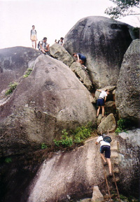
Gunung Datuk rock obstacles which form the summit. |
| Location | Negri Sembilan, Malaysia |
|---|---|
| Height | 870 m |
| Terrain | Forest trails, rope obstacles |
| Recommended duration | 1 day |
| Ease of access | Taxi/cab to Hutan Lipur Gunung Datuk |
| Special equipment | None |
| Good | Good view at summit; Rock obstacles at summit makes it an interesting finale |
| Not so good | Bottle neck at summit rock obstacle if it gets crowded |
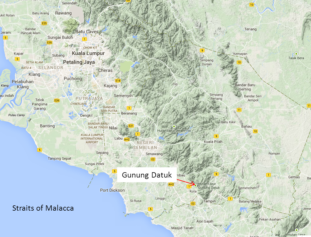
Gunung Datuk is situated at the end of the Titiwangsa range. Terrain view from Google Map. |
A summit with a 360 degrees view of the surrounding landscape, a rewarding sight at the end of a short and intensive trek. Gunung Datuk is located in Kumpung Batang Nyamor, Gadung, about 21km from Rembau Town and 15km from Tampin Town, in the state of Negri Sembilan. A small mountain that stands near the end of Peninsula Malaysia main range (Titwangsa range), at the west of the mountain is the flat plains that goes to the Straits of Malacca and the Titiwangsa range flanking the other directions. The summit of the mountain was once used by Dato Perpateh Nan Sebatang to gather Ketua-ketua Adat (Customs Leaders) to announce the future Dao Lembaga (clan chief) in 13724. The distance to the summit is relatively short and a fit individual can easily reach the top in about an hour. The huge rocks forming the summit presents an exciting challenge at the end of the forest trek.
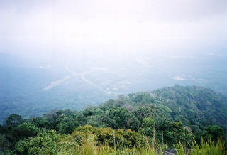
View from Gunung Datuk summit |
The starting point of the trek is at Hutan Lipur Gunung Datuk or recreational forest Gunung Datuk where there is a registration counter and toilet facilities. Some temporary local food stalls may be set up at the car park during the weekends to cater for the visitors to the hill. A flight of stairs that goes down to a stream marks the start of the trail. There is a small dam that runs across the stream which you can walk on to get across without getting wet. A short walk along relatively undulating terrain brings you to a steeper ground. The steep ascent seems endless and can be physically taxing. However, after about half an hour to an hour of trekking, the terrain gives way to gentler section that will bring you to the false summit. There is a broken down small hut and a clearing where some big rock walls stands. This clearing is large enough for about four tents and it is suitable for camping. However, water needs to be brought up from the base of the hill. The true summit is at the top of the rock walls. There are some ropes and ladders to help you get to the top. If there are many visitors, you may have to wait for your turns to get to the summit. Some trekkers choose to start the trek before sunrise1 to avoid the crowd and to catch the sunrise from the summit.
Very few mountain summits in Peninsula Malaysia can match that of Gunung Datuk. Devoid of vegetation, the Straits of Malacca can be seen on a clear day2. There is an imprint on the rock at the summit that looks like a footprint3. According to myth, the footprint is made by legendary warrior Hang Tuah who moves from place to place by jumping on mountains4.

|
|

Via Train
Take train to Seremban. You may check out the train services, prices and dates on Malaysia Railway
Via bus
Take bus to Seremban. You may check out the bus services, prices and dates on http://www.busonlineticket.com
From Seremban to Kota4
Via bus: Take a bus to Rembau from Terminal 1 Bus Station and stop at Kota; cost around Rm4.
Driving instruction from Singapore (As of Jan 20085)
- Take North South Highway (either from 2nd link or Causeway) in the direction of Seremban and KL.
- Drive all the way. You will pass exits for Muar, Ayer Hitam, Yong Peng, Muar, Segamat and Ayer Keroh. Your desired exit is the Tampin Exit.
- At the Tampin exit, after exiting the toll booth and making your (presumably) second contribution to Malaysian GDP, you should reach a roundabout. The 9 o'clock junction should be toward A'Famosa/Malacca/Ayer Keroh. I can't remember precisely. Do not take this exit. Take the 3 o'clock junction. This should be toward Tampin.
- After about 10 or 15 min, you will reach a T-Junction. You have now arrived at the old Trunk Road from Johore to KL, aka Highway 1. Take the left turn. This is toward Seremban/Senawang/Rembau. Do not take the right turn, which is toward Tampin. You're now heading approximately northwards.
- Travelling on highway 1 toward Rembau, within 10 or 15 min, or even earlier, you will reach a T-Junction without traffic lights. There will be a sign indicating that this is the turning for Gunung Datuk. Take this right turning off the highway. Should you overshoot, you will also see this sign going southwards after u've turned back. This T-junction is crucial. You must not reach any small towns or villages. If you do, you'll definitely have overshot. I believe the first village you hit if you overshoot should be Pedas. Look out for a sign mentioning Gunung Datuk.
- Okay, this part is a bit more difficult. After taking this right turn, you'll find yourself on a small country road. You should pass a muslim cemetery on your left. (if I recall correct). By this time you would have seen a mountain range to your front and left. Datuk is part of this range. After about 15-20 min you will see another sign (again saying gunung datuk) directing you left into a rubber estate. This small turn-off used to be opposite a small bus stop. This sign is crucial if you've no-one with you who's been there before.
- You're now on a small rubber plantation road. If u meet a car, either will have to pull to the side to make way. The plantation should remind you of the blair witch project! Hahaha. After about 10-15 min you'll reach the Base of Gunung Datuk. This will be preceeded by a small clearing which is kind of a broad clearing in the forests running in a long line. Immediately after the clearing is a rather steep incline which will flatten out into a parking area. Parking area has a stone and signboard in the centre.
- You have reached the foot of Gunung Datuk. Sign in at ranger station and have fun. Enjoy the view from the top!

| Duration(mins) | Description | Instructions | Remarks |
| 00 | Carpark; Stairs leading to a stream | Go down the stairs and cross the stream | |
| 10 | Start of steep ascent | ||
| 30 | Gentle ascent | ||
| 30 | Broken hut and rock walls | Use ropes and ladders to climb up rock walls | |
| 10 | Summit |

Reach summit by 10 am
Return to town for lunch

As of June 20116
| Climbing fees | : Rm5.00 per person |
| Camping Fee | : Rm3.00 per person |
| Tent hire (4-men tent) | : Rm5.00 per tent |
| Climbing guide (Not compulsory) | : less than 20 people, Rm60 : 25 to 50 people, Rm120 : more than 50 people, Rm180 |
Contact Information6
Koperasi Gunung Datuk Rembau Berhad (Gunung Datuk Office)
Tel: 06-4381046
Email: gunung_datuk@yahoo.com

- Light weight clothes
- First Aid Kit
- Extra clothing
- Rain gear
- Swiss Knife
- Insect repellent
- Sufficient water (about 2L) for the trek