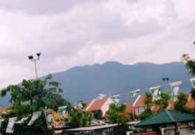
Gunung Angsi can be seen along the road from Seremban to Kuala Pilah(20 March 2004) |
| Location | Negri Sembilan, Malaysia |
|---|---|
| Height | 825 m |
| Terrain | Forest trails, obstacles |
| Recommended duration | Half day |
| Ease of access | Taxi/cab |
| Special equipment | None |
| Good | Relatively easy |
| Not so good | Litters and rubbish at the summit |
A half-day introduction to trekking on Malaysia's mountains complete with obstacles and stream crossings. The state of Negri Sembilan contains many hills and mountains. One of the most popular hills for the locals would be Gunung Angsi, located in the Ulu Bendol Recreational Forest about 20km from the town of Seremban. The popularity of this hill is obvious with the developments at its base. There is a carpark with stalls and walkways that lead to a Ranger's hut.
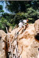
Gullies near to the top of the hill (20 March 2004) |
The trek up this hill is quite straightforward and pleasant. After leaving your name and particulars at the Ranger's hut at the start of the trek, the trail follows a stream halfway up the hill which you need to cross several times. With some deliberate and careful balancing on the rocks, you should be able to cross the streams without getting your feet wet. This part of the trek is quite simple and the ascent is rather gradual. Leaving the stream behind, the ascent becomes steeper as you walk up a ridgeline which leads to the summit of Gunung Angsi. This part of the trek is quite tiring and monotonous. Closer to the summit, deep gullies provide some challenges which you need to overcome with the help of some woodworks. The summit of Gunung Angsi can be reached in about 2.5 hrs. There is a clearing at the top of the hill but tall trees and vegetation at the perimeters block out most of the views. There are some openings which offer a view of other hills in the vicinity. According to the locals, another trail from the summit would lead to the bottom of the hill. However, the end of that trail is about 3km from the main park area.
The popularity of this mountain and relatively ease of access to it unfortunately, led to some side effects. Piles of trash left can be seen on open areas and on the summit. Soil erosion is also obvious with gullies forming near the summit. Fortunately, there are not many mosquitoes on the trek and leeches are uncommon.
Gunung Angsi trek encompasses various elements of a Malaysia mountain trek with river crossings, walking on ridgeline, dull ascent and obstacles at the end. It is simple enough for first timers to give it a try although a reasonably fitness will make the trek less tiring. The town of Seremban is only an hour's drive away from Kuala Lumpur, the capital of Malaysia. There is still time left to return to the city after the half day trek to relax.
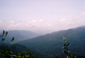
Other hills can be seen from the summit of Gunung Angsi (20 March 2004) |

|
|

Take train to Seremban. You may check out the train services, prices and dates on Malaysia Railway
or
Take a bus. You may check out the available bus services, prices and dates on http://www.busonlineticket.com
To Ulu Bendol
Via Cab:
Cost: Rm 15 (accurate as of Dec 2005)1
Via Bus:
Take Transnasional bus service towards Kuala Pilah
| Cost | : | Rm 2 per person |
| Bus Interval | : | 20 mins |
| Duration | : | approx. 45 mins |
| Remarks | : |
Bus is located at Berth 40-42. Ulu Bendol Park is on the right. The road before this is a long series of bends with plantations on both sides of road. |
| Other bus companies | : |
Southern (yellow and blue buses) United (yellow and red buses) |

| Duration (minutes) | Description | Instruction | Remarks |
|---|---|---|---|
| 00 | Carpark and stalls | Cross a bridge behind the stalls. Follow the path upstream | |
| 05 | Ranger's Hut | Write down particulars. Trek along trail upstream | |
| 50 | Pondoks and a stream beyond | Cross stream | |
| 10 | Old logging trail at a T-junction | Turn left and walk along the logging trail | |
| 05 | Open land about size of a two basketball courts | Look out for red tape on the left which mark the trail. | |
| 03 | Small stream | Cross stream and trek up along a ridgeline | |
| 85 | Summit |
Total time taken to reach summit from starting point: about 2 hrs 40 mins
The above timings vary from individual fitness to size of group. It should only be used as a very rough guide.
March 2004. Courtesy of The Mountain Trekker1

RM 5.00 per person (Oct 2012)2

- 2L drinking water
- First Aid Kit
- Toilet Paper
- Extra clothing
- Rain gear
- Swiss Knife
- Insect repellent
- Leech repellent (eg. Vinegar solution, salt)