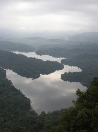
View from Bukit Tabur West. |
| Location | Kuala Lumpur, Malaysia |
|---|---|
| Height | 450+ m |
| Terrain | Mixed forest trail, rock obstacles. |
| Recommended duration | Day hike |
| Ease of access | Cab or private vehicle required |
| Special equipment | None |
| Good | Nice view of Klang Gates Dam. Close to Kuala Lumpur city center. |
| Not so good | Potentially dangerous as some of the ridges which you are walking on are very narrow. |
Bukit Tabur west ridge(05 September 2009) |
Make a day trip to the longest quartz ridge in the world at the outskirt of Kuala Lumpur city center. Bukit Tabur also known as "The Crystal Hill", Bukit Hangus or "The Dragon's Backbone" is located in Taman Melawati and is part of Klang Gates Quartz Ridge. The prominent ridge can be seen from Kuala Lumpur Middle Ring Road 2. This ridge is a popular hiking ground for the city residents and the reason is clear once you step on top of the ridge. On one side is the flooded forest hills behind the Klang Gates Dam covered by early morning mist over the tranquil lake. On the other side is the smog and dust covered Kuala Lumpur city center bustling with activity.
The steep sides of the ridge have managed to keep development at bay and the area is relatively clean despite its popularity. Wildlife is still abundant here despite its proximity to the city. Snakes, monkeys and forest birds are commonly found here and lush green moss and lichens still covers the side of the trail.
Getting on the ridgeline is the easy part. Moving along the ridgeline is where the challenge and dangers lurk. The quartz ridge is sharp with steep, vertical falls on both sides. There are no tall, rainforest trees growing on the ridgeline except for shorter trees and bushes that managed to find small footholds in the cracks and crevices on its side. Parts of the ridges comprises of exposed rocks that require some basic rock climbing skill to overcome but with very little room for error. Ropes can be found tied to the rocks to facilitate climbing over the rock face. Since the integrity of the ropes is unknown, cracks in the rocks may provide a more secure handhold. Any lapse in concentration may result in a fall several tens of meters down the side. News of hikers who have fallen down the ridge is unfortunately common and in 2014, the state government requires hikers to apply for a permit to climb up the ridge. How this will mitigate the frequency of accident is anybody's guess.
The best time to come for this trek will be in the early morning. Once on top of the ridgeline, you may catch the morning mist rising from the lake below. The morning air is also fresher before the city comes alive. Since there is very little vegetation cover, it is best to complete the trek before the heat from the sun gets more intense towards noon. The trek on Bukit Tabur is more technically challenging than physically challenging. It provides a natural getaway from the shopping and the traffic of the urban city while still close enough to get back to its comfort after the trek is over.
|
Trivia
The Klang Gates Ridge is built almost entirely of quartz and may be the longest quartz ridge in the world spanning 14 km long and 200 m wide4. Efforts are being made by the state government to declare it a World Heritage Site as the longest quartz ridge in the world under the United Nations Educational, Scientific and Cultural Organisation (UNESCO)5. |

Trekking is only allow on Thursday, Saturday, Sunday and public holiday from 8.30 a.m. to 5p.m.

|
|

- Hiking and stuff, 31 July 2014.

Take a bus to Kuala Lumpur bus terminal. You may check out the available bus services, prices and dates on http://www.busonlineticket.com
To Bukit Tabur Entrance2
Via own car or cab:
- Exit MRR2 at Taman Melawati
- Roundabout, exit at 9 o'clock - Roundabout, exit at 12 o'clock - T-junction, turn right. Continue until entrance of Puncak Niaga facilities
See details here,
View larger map here

| Duration (mins) | Description | Instructions | Remarks |
|---|---|---|---|
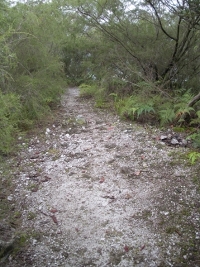
| 00 | Outside the entrance of Klang Gates Dam (See picture 1 and 2) | Facing the entrance of Klang Gates Dam, there is a small drain on the left side of the road. The trails starts from the end of the drain. This trail will lead you up to the ridgeline. | |
| 40 | Path that seems to end at a big rock wall. | The trail runs down the right side of this rock. | |
| 30 | Rope down followed by rock face about 5 storeys high | Climb up the rock face. | This is the start of many rock faces to climb up and down |
| 80 | A Y-junction (See picture 11) | Go straight to reach the highest point of this ridge | Turn left to go down the hill. |
| 10 | Highest point (not very obvious) (See picture 12) | Turn back to the earlier T-junction | |
| 10 | Y-junction | Turn right | This trail can be slippery but not technical. |
| 25 | Old hut.(See picture 14) | ||
| 10 | House | ||
| 10 | Back to main road. | Turn left to go back to starting point of trek |
Useful Timings (September 2004. Courtesy of The Mountain Trekker3)
| Starting point to highest point | : approx. 2 hours 10 minutes |
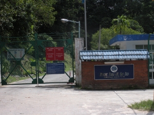 Picture 1: Klang Gate Dam(05 September 2009) |
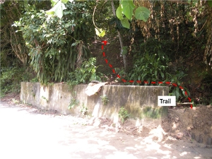 Picture 2: Red dotted line showing the trail from the starting point(05 September 2009) |
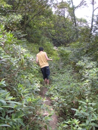
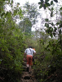 Picture 3: Going up to the ridgeline(05 September 2009) |
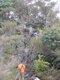 Picture 4: One of many obstacles(05 September 2009) |
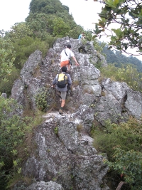 Picture 5: Another obstacle(05 September 2009) |
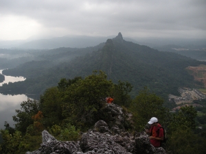 Picture 6: Left is the lake, right is the residential area and center is the East ridge(05 September 2009) |
Picture 7: Lake(05 September 2009) |
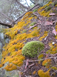 Picture 8: Moss and lichens surviving by the side of the trail along the ridgeline(05 September 2009) |
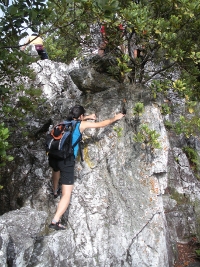 Picture 9: More obstacles(05 September 2009) |
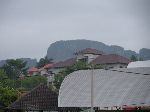
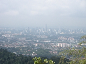 Picture 10: Kuala Lumpur with the twin tower visible at the distant(05 September 2009) |
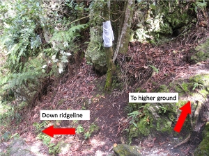 Picture 11: Y-junction. Left route would lead down the ridge and right route would lead to the highest point(05 September 2009) |
 Picture 12: The highest point but not much can be seen from here(05 September 2009) |
 Picture 13: Slippery path down the side of the ridge(05 September 2009) |
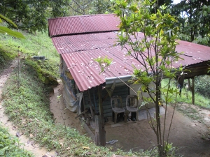 Picture 14: Hut, a sign that civilization is not far away(05 September 2009) |

Return to starting point about 11 am

Cost: Rm 5
Permit Application office:
KM 11 (Batu 9), Jalan Cheras-Kajang,
43200 Kajang, Selangor Darul Ehsan.
Tel. : 03-9075 2885
Fax : 03-9075 6022
See location on street directory

- First Aid Kit
- Extra clothing
- Rain gear
- Cap/Hat
- Swiss Knife
- Insect repellent
- Water container


| Date | Description | Source |
|---|---|---|
| 14 Feb 2013 | A search-and-rescue team spent 12 hours to rescue female hiker Noor Hasmahani Hashim who was stuck in a tree after falling 10m down a ravine. | The Star Online |
| 10 October 2009 | A 51 year old man get away with light injuries thanks to bushes that cushioned his fall after tumbling down 30 m. | The Star Online |
- Selangor State Forestry Department. Click here. [08 Dec 2014]
- Hiking at Bukit Tabur. Backpacking Malaysia. Click here. [08 Dec 2014]
- The Mountain Trekker - Bukit Tabur
- http://mcleon.tripod.com/quartz-ridge.htm. [08 Dec 2014]
- Klang Gates Ridge in the spotlight. The Star Online Click here. [08 Dec 2014]