Chulu East, Chulu West and Chulu Central as seen along the way to Yak Kharka(December 2003). |
| Location | Annapurana Circuit, Nepal |
|---|---|
| Highest point | 5400 m |
| Terrain | Highland dusty trail |
| Recommended duration | At least 15 days |
| Ease of access | Bus ride to starting point of trek |
| Special equipment | None |
| Good | Scenic. Nice weather. |
| Not so good | Dusty trail |
The Annapurna Circuit is one of the most popular treks in Nepal. The whole route covers a distance of 300 kilometers around the perimeter of the Annapurna mountain range. The Annapurna Circuit generally takes 18 days to complete on foot although it can be completed in as little as 16 days. Most people cover the Annapurna Circuit in a counterclockwise direction up Marsyandi River, cross the Thorong La high pass and down into the Kali Gandakhi Gorge, reputed to be the deepest gorge in the world. The journey down Kali Gandakhi River is also known as the Jomsom Trek and is suitable for people who do not want to cross the high pass.
Along this trek, some of the world's highest mountains can be seen such as sixth Dhaulagiri (sixth), Manaslu (seventh) and Annapurna I (tenth). The magnificent snow-capped mountain ranges dominated the landscape reducing the settlements to mere speck in the Himalayas. The trek sees the gradual changes in the landscape and vegetation as you go higher. At the fertile lower region along the river, civilization has carved out terraces on the slopes of the hill for agriculture. Going up river, conifer forest took over before giving way to the more resilient Juniper trees at higher altitude. Up the Thorong La pass, the cold and high wind is too much for any vegetation to survive and what remains is a barren landscape.
This journey brings you to the different cultures in Nepal. The upper region of the trek follows the ancient trade routes between Nepal and Tibet, thus the influenced of Tibetan culture is apparent with Bhuddist chorten and mani walls forming part of the landscape. The village of Muktinath is one of the most sacred sites for Bhuddist and Hindu pilgrims in Asia.

|
|
| Route Description (As of December 2003) |
|
Day 1: Besisahar (790m) to Ngadi (930m), 7hrs From Besisahar, the road quickly deteriorates into sand and dust road. Buses still make use of the road although we travel on foot. Crossing a bridge at Khudi, we leave the vehicular passable road behind. Along Marsyandi River, there are many terraces carved into hillside for growing of crops. Mules carrying heavy loads on their back are a common sight along the footpath throughout the trek. When mules meet men, mules have the right of way. Day 2: Ngadi (930m) to Jagat (1300m), 11hrs Moving up Marsyandi River. Although much of the land is still cultivated, there are still pockets of forest. The trail is dusty and littered with animal dung. In December, when the growing season is over, mound of dried stalks can be seen piled in the middle of the terrace field. Poinsettias with their bright red leaves around their flowers are in full bloom. The orange trees growing in the settlements are bearing fruits. Children and adults along the path are selling their oranges anywhere from Rs2 to Rs10 each. Day 3: Jagat (1300m) to Dharapani (1900m), 11hrs The journey continues into the forests and evidence of Tibetan influences started to show. There is a long, tiring ascent before reaching the gate to the Manang District. A wide, picturesque valley with a settlement in it presents itself at the gate. The view is a treat to the eyes after the boring ascent. Day 4: Dharapani (1900m) to Chame (2670m), 7hrs At Bagarchhap, a short distance after Dharapani, Annapurna II can be seen. The trek from here is less dusty as compared to previous days. Conifer forest start to dominates the landscape as we trek towards Chame. Other trees shed their leaves in preparation for the winter months while shrubs disperse their seeds in the wind. At Chame, there is a police and army check-post. Visitors have to show their trekking permits and register in their book before allowed passage into the settlement. Chame is a large settlement with many stores selling anything from batteries, snacks to winter wears. Peaks such as Kang Guru and the Lamjung Himal can be seen at Chame. Day 5: Chame (2670m) to Pisang (3300m), 6.5hrs From Chame to Pisang, the terrain starts to open up as we leave the deep narrow valley behind. The path is wider here and there is very little cultivation of crops as conifers cover most of the landscape. Temperature can drop below freezing point at night at this time of the year. At 3300m, it is possible for visitors to acquire acute mountain sickness (AMS). Day 6: Pisang (3300m) to Manang (3540m), 5hrs As the valley continues to opens up, more snow capped mountains come into view. At the end of the Pisang settlement, Pisang peak shows itself on the right side while Annapurna II and Annapurna IV can be seen on the left side of the trail. A third of the way to Manang, Annapurna I and Annapurna III can be seen. In Honde settlement, midway to Manang, there is an airstrip and also a police check-post. Once again the trekking permit have to be checked and the registered. The huge massif of Annapurna III watches us as we move to Manang. At Manang, Gangapurna Himal showed itself complete with its icefall. Day 7: Manang (3540m) This is the acclimatization day. A trip up the side of Gangapurna will aid the acclimatization process. A beautiful, turquoise glacial lake formed by the melting Gangapurna icefall can be seen near Manang. Going up to 3800m, the Chulu East, West and Central can be seen behind Manang. Khatung Kang, Shel Kang and Yakawang peak, which the Thorong La Pass runs through, can also be seen. Towards the east, the distant peak of Manaslu is seen. Day 8: Manang (3540m) to Yak Kharka (4100m), 5hrs From Manang, the Marsyandi River ends and the trail turned northwest, following the Jharsang Khola. The trek follows the spurs that run down the Chulus. Juniper trees give way to patches of shrubs that struggles to survive under the harsh condition presented at such altitude. Frozen stream that runs down the hillside pose slippery obstacles for the trekkers to cross. Crossing the Karche Khola, the Chulu West, Chulu Central and Chulu East can be seen in its full majesty. Day 9: Yak Kharka (4100m) to Thorong Phedi (4575m), 5.5hrs The trek follows Jharsang Khola upstream. The terrain is quite barren and it can get quite windy for this part of the trek. The hardest part of this trek is perhaps the steeper ascend after crossing a bridge on Jharsang Khola. The trail consists of scree-covered slope that runs all the way to Thorong Phedi. Day 10: Thorong Phedi (4575m) to Thorong La pass (5400m) to Muktinath (3800m), 12hrs The push for the high pass may start as early as 3am. The temperature coupled with the wind can drop to as low as -13°C. Thus trekkers who intend to travel at such early hours need to have the appropriate clothing to deal with the cold especially gloves and socks. Although it may not be as windy at such early hours, there is still wind that is very dry and very cold. A scarf that covers the mouth would be very much appreciated. Prayer flags and a small stone hut mark the Thorong La pass. Khatung Kang peak can be seen clearly beside the high pass. The rest of the way down to Muktinath can be very long and tiring. The trail is runs mainly down scree slopes that are difficult to walk on. Upon reaching Muktinath, the Dhaulagiri I can be seen beyond the settlement. Over here, there is a police check-post where there is the usual procedure. Day 11: Muktinath (3800m) to Mapha (2670m), 7hrs From Muktinath, it is back to the dusty roads. For most part of the trek, it consist of walking on open terrain where the wind is strong and the shrubs have to cluster into small domes on the ground. As we enter the Kali Gandaki River, Dhaulagiri I slowly disappear behind the lower ridges. The wind is even stronger and it picks up sand and dust, lashing at anybody who dares venture into the valley. It is only at Jomsom where there is a break from the sand storm. There is an airport there and also an army check-post and police check-post. Jomsom is a relatively large settlement with many stores. Along the way, there are many apple trees with fruits hanging from its leafless branches. Marpha is another hour of walk away. The settlement is smaller but less windy and dusty. Day 12: Mapha (2670m) to Kalopani (2530m), 7hrs The trail follows the Kali Gandaki River downstream. It is less windy and with the drop in altitude, conifer trees begin to reappear. Approaching the settlement of Tukuche, the snow peak Tukuche and Dhaulagiri I peak comes into view. Nilgiri South, Nilgiri Central and Nilgiri North can also be seen. Following the river course, there are a few slight ascends as the trail crosses the spurs. At Kalopani, Annapurna I and Baraha Shikhar peak rises behind the ridges. Day 13: Kalopani (2530m) to Tatopani (1200m), 9hrs The trail continues to descend moving along the course of the river. Midway to Tatopani, there is an Army check-post. Tatopani is quite a large settlement. There are many stores selling many different items, from jewellery to toilet papers. There is even a volleyball court in the settlement. Day 14: Tatopani (1200m) to Ghorapani (2775m), 8.5hrs The trail breaks off from Kali Gandaki River at Tatopani as we head towards Ghorapani. It is continuous ascend for the journey to Ghorapani with very few slight descend. As we approach Ghorapani, the trail runs rhododendron forest. But as this is the winter season, the rhododendrons are not flowering. Upon reaching Ghorapani, Annapurna South and Dhaulagiri I can be seen. Day 15: Ghorapani (2775m) to Naya Pul (1070m) This is the last day of the trek to Naya Pul where the bus will be waiting to bring us to Pokhara. The beautiful peak of Machhapuchhre peak (Fish Tail) can be seen from a distance along the way down. From Ghorapani, it is a long descend down to Tirkhedhunga settlement where we meet the Bhurundi Khola (river). The trail follows the river and there are slight changes in the altitude of the trail. |
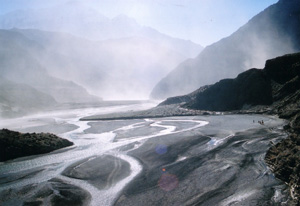
Valley that leads to Jomsom. Strong wind in the valley picks up sand that lashes at any exposed skin (December 2003) |

UNIVERSAL TRAVEL CORPORATION PTE LTD
101 Upper Cross, People's Park Centre
#B1-66
Singapore 058357
Tel: 65356004
Fax: 65327443
TIMS (Trekker's Information Management System) Card[Ref. Trekking Agencies Association of Nepal]
Blue TIMS cards for Group Trekkers: Rs 1000 per person
Green TIMS card for individual trekker: Rs 2000
TIMS cards for Group Trekkers from SAARC countries: Rs 300 per person
TIMS cards for individual trekker from SAARC countries: Rs 600 per person
Entry Permit to Trek in Conservation Areas [Ref. National Trust for Nature Conservation]
Entry Fee (Per Person) to visit Annapurna Conservation Area (ACA), Manaslu Conservation Area (MCA) and Gaurishankar Conservation Area (GCA),
For SAARC Nationals: Nepali Rupees 200.
For other Nationals (other than SAARC countries): Nepali Rupees 2,000.
Download Entry Permit Forms from National Trust for Nature Conservation website
Additional Trekking Permit for Upper Mustang
Mustang District:
For the first 10 days per person US $500. Every subsequent day per person US $50, Or equivalent convertible foreign currency.
Other miscellaneous cost (as of year 2003)
Tippings: Rs100 per day on the trek per trekker
Tips are given to the Sirdar who would distribute the money.

| Equipment | Quantity | Description/Model | Remarks |
| Clothings | |||
| Polar Fleece 200 | 1 | Nepali thick fleece | |
| Polar Fleece 100 | 1 | Nepali sleeveless fleece | |
| Down Jacket | 1 | Provided | |
| Thermal Long-johns | 3 pairs | Polypropylene, wool | |
| Light weight fleece pants | 1 | Nepali fleece | |
| Gortex Jacket | 1 | ||
| Gortex Pants | 1 | ||
| Footwear | |||
| Trek-in boots | 1 pair | ||
| Woolen socks | 2 pairs | ||
| Socks inner liner | 2 pairs | ||
| Sandals | 1 pair | Nepali gortex | |
| Gaiters | 1 pair | ||
| Gloves | |||
| Fleece gloves | 1 pair | Pro CAM-FIS, Polartec Windbloc | |
| Inner liner gloves | 2 pairs | Polypropylene | |
| Waterproof ski gloves | 1 pair | The North Face Gor-tex | |
| Mittens | 1 pair | ||
| Headwear | |||
| Hat | 1 | ||
| Scarf | 1 | SAF camou scarf | Use to protect the neck against UV rays. Other bandanna may be better |
| Fleece hat | 1 | Nepali fleece hat | |
| Balaclava | 1 | Mammut Facemask | |
| Sleeping accessories | |||
| Sleeping bag | 1 | Provided | |
| Insulation mattress | 1 | ||
| Eye wear | |||
| Sunglasses | 1 | Reebok Ventra | |
| Hydration | |||
| 1L Bottle | 1 | SIGG | |
| 0.6L Bottle | 1 | SIGG | |
| Neoprene insulating pouch | 2 | SIGG | One for each bottle |
| Misc | |||
| 65L Expedition backpack | 1 | Lowe alpine Frontier 65 +15 | |
| 40L Daypack | 1 | Salomon SK40+10 | |
| Pocket Knives & Tools | 1 | Richartz maxi 7 | Maybe better to get one with pliers and screw drivers |
| Watch | 1 | SUUNTO Vector | Excellent to have, got altimeter which is very useful |
| Trekking pole | 1 pair | Komperdell Northern Light | |
| Headlamp | 1 | Petzl Tikka | Bring extra batteries |
| Personal Care | |||
| Sun block | 1 | Coppertone SPF 45 | |
| Lip Screen | 1 | Banana Boat SPF 30 | |
| First Aid kit | 1 | ||
| Toiletries | 1 set | ||
| Umbrella | 1 | ||
| Passport size photo | 2 | 1 for visa, 1 for trekking permit | |
| Nail clipper | 1 | ||
| Nutrition | |||
| Vitamin C Bioflavonoids | Blackmores | ||
| Gingko Forte 2000 | Blackmores | ||
Medications
The following are the medicine brought to the expedition. It is important that all the members in the team are aware of how to use the appropriate medicine. Where possible, the type of medicine, its usage and dosage should be clearly labeled on the medicine.
Diarrhoea
Vomiting
Fever
Sorethroat
Cough
Incessant Cough
Pain
Gastric
Acute Mountain Sickness (AMS)
|

| Date | Description | Source |
|---|---|---|
| 18 October 2014 | Nepal Annapurna: Trekking disaster toll reaches 39 | BBC |
| 16 October 2014 | At least 23 hikers are dead along the Annapurna hiking circuit. | National Geographic |