Through the valley on the way back from base camp |
| Location | Annapurana Base Camp, Nepal |
|---|---|
| Height | 4130 m |
| Terrain | Highland dusty trail |
| Recommended duration | At least 11 days |
| Ease of access | Bus ride to starting point of trek |
| Special equipment | None |
| Good | Scenic. Nice weather. |
| Not so good | Dusty trail |
Blog post, Jonathan from Singapore
Trek: 22nd Dec 2001 to 1st Jan 2002
Annapurna standing at a height of 8091m is the 9th highest mountain in the world. In Nepali it means, "rice full". It is also the first mountain over 8000m to be scaled by man. The base camp is at an altitude of 4130m and it is easily reached after 4 days of trekking. It is also the most popular trek in Nepal.
The trek to Annapurna base camp is relatively easy. No technical skills are required to reach the base camp although a steady foot is a great advantage on some uneven terrains. Villages and teahouses dotted the route at regular intervals provide both food and lodging. Many of the teahouses provide hot shower especially those at the lower reaches of the mountain. You do not have to be very fit to go for this trek. With a guide and the help of porters to carry your heavy gears, almost anybody can reach the base camp. Of course, the fitter you are, the more you will enjoy the trek.
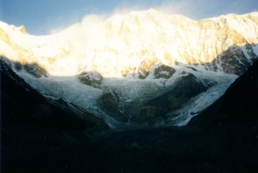
The scenery it offered is also very beautiful and varied. For most part of the trek, you will be walking pass terraces on the side of the mountains where the locals grow their crops. You will be able to see the mountain of Machhapuchhre(6993m), Annapurna South(7220m) and Hiunchuli(6441m) along the journey. If you are going from Ghorapani to Annapurna base camp, you can even see the whole of Dhaulagiri(8167m) range. From the base camp, it is possible to see the summit of Annapurna I(8091m) as well as several other lower, but equally magnificent snow covered peaks.
When I went for the trek, it is already winter. It is quite warm when you are trekking under the sun but when you are in shade or the wind is blowing, you will start to feel cold. Thus during the evening, once the sunrays are blocked by the hills, the temperature will dip rapidly. Nearer to the base camp at about 3000m, frost covered vegetations can be seen. As the trek goes higher, there are more patches of snow until huge patches of snow are seen everywhere at the base camp. At night, the temperature at the base camp drops below zero degrees (My water is frozen in the container when I woke up next morning!) and it is important to have a down sleeping bag (most agency provides down sleeping bag and down jacket).
Other then the cold, there are two other unpleasant things that one have to endure, dust and dung. They are everywhere. As it was a winter trek, there was no rain and the region was very dry. A small dust twister was set off each time the person in front of you took a step. Your shoes would be brown with dust and your whole body would also be covered with a fine layer of dust. During the trek, small herds of goats, ponies and even buffaloes led by the local herders shared the same path you are taking. Thus with the huge traffic of animals, comes huge volume of their waste products. The smell can be overpowering at times and it is difficult to avoid stepping on them throughout the trek.
On the whole, Annapurna base camp trek is a very good and relaxing introduction to trekking in the Himalayas. The scenery it offered is also breathtaking. There is a variety of food found in the teahouse and their bed is generally comfortable. Their free hot shower is a luxury and very much appreciated especially during winter treks. A word of caution though, the condition in the mountain ranges can be unpredictable, landslide do occurs especially during the summer period and tragedy do happens. I have seen an avalanche near the peak of Machhapuchhre during my trek and it is a reminder that traveling in the mountains does have its risk.

|
|

|
Day 1 Nayapul to Tirkhedhunga(1540m) The trek is quite short and easy. There are not many steep ascends and Machhapuchhre can be seen during the initial part of the trek. The trail runs parallel to a river and is safe to walk on. Day 2 Tirkhedhunga to Ghorapani(2860m) During the first 5 hours of the trek, it is all steep ascend along the terraces after an initial descend to cross a bridge. After which the ascend starts to get more gentle. There is not much to see except terraces on the surrounding slopes and a glimpse of Annapurna South, Hunchuli and Machhapuchhre. Day 3 Ghorapani to Tadapani The trek to the top of Poonhill(3210m) to catch the sunrise is very tiring. But the view from there is breathtaking. Annapurna South, Machhapuchhre and the Dhaulagiri range can be seen very clearly from the top. But for those who did not make it to the top, there is still another chance to see these mountains after ascending to the top of a ridge on the way to the next village. After the traveling on the ridgeline for a few hours, it is all descending into a deep gorge before a steep ascend to Tadapani.
Day 4 Tadapani to Chomrong(2170m) There is an initial steep descend for about 2 hours to a river where there is a bridge followed by ascending for another 2 hours. The route is relatively level all the way to Chomrong for the last hour. This trek passes through many terraces. Chomrong is also the village where there is the junction that leads to Ghorapani or back to Pokhara. Day 5 Chomrong to Doban(2606m) Again the initial part of the trek is a steep descend to a river for about an hour. From the river, it is mostly ascending to Doban. For the first few hours of trek to Sinuwa, the journey is through terraces. After which the land is wilder as the trek leads into Modi Khola valley, which runs all the way to the Machhapuchhre base camp(3700m). There is nothing much to see in the valley as the high grounds on both sides of the valley blocks the view of any mountain. The ground here is also wetter thus there are less dust floating about. Day 6 Doban to ABC(4130m) The trek from here is more interesting. Frost on the vegetation starts to increase until patches of ice are seen. The terrain also starts to change from trees to shrubs until finally short grasses after MBC. The beautiful Machhapuchhre mountain can be seen clearly on certain portion of the trek and the peak of Annapurna III(7555m) also slowly comes into view. It might be a better idea to stay at MBC instead of ABC so that the gain in altitude is not as great.
Day 7 ABC to Bamboo(2510m) It is just back trekking from ABC all the way to Chomrong. Day 8 Bamboo to Jhinu Danda(1760m) After Chomrong, it is a very steep descends to Jhinus Danda. There is a hot spring about 15 min trek downhill from Jhinu. The temperature of the water is comfortable and it is very relaxing to dip yourself in the hot spring. Day 9 Jhinu danda to Landrung(1640m)It is a downhill trek to a bridge and the trail from there is relatively level. There is not much to see as the trek leads away from the mountains. After crossing a second bridge, the trail then starts to ascend to Landrung. From Landrung, only Annapuna South, Hiunchuli and Machhapuchhre can be seen. Day 10 Landrung to Dhampus(1770m) The initial trail from Landrung to Dhampus is through terraces. The trek is relatively gentle with only one steep ascend midway through. Once again there is not much scenery to be seen until Dhampus. From Dhampus, the whole of the Annapurna range can be seen. With Annapurna South, Annapurna I and Hiun Chuli to the left, Machhapuchhre at the center and Annapurna II, Annapurna III, Annapurna IV and Lamjung Himal to the right. Many tourists come to Dhampus from Pokhara to see the beautiful Annapurna range. Day 11 Dhampus - Phedi From Dhampus, it is all descending passing through terraces along the way to Phedi, which is the main road and the end of the Annapurna base camp trek. From Phedi, it is possible to catch a cab or a local bus to Pokhara. |

| Mountains that can be seen during the trek | ||||||||||||||||||||||||||||||||||||
From Poonhill and journey from Ghorapani to Tadapani
From Base camp
From Dhampus
From almost every location Annapuna South, Machhapuchhre and Hiunchuli |

Pac-west Travel(s) Pte Ltd
60 Eu Tong Sen Street
Furama hotel shopping centre
#02-05 Singapore(059804)
Tel : (65) 5361889
Fax: (65) 5361350
Webpage: http://www.pacwest.com.sg
E-mail : pacwest@singnet.com.sg

- First Aid Kit
- Winter wear for temperature below -10 °C
- Sleeping bag for temperature below -10 °C
- Extra clothing
- Extra footwear eg. sandals
- Rain gear (umbrella)
- Windbreaker/Jacket
- Swiss Knife
- Water for the trek
- Contingency food
- Torchlight